Discoveries at Bimini
Columns, Marble Building Ruins, and Possible Building Foundations in 100 Feet of Water
By Dr. Greg Little
With the 1968 announcement of the discovery of the Bimini Road, which is a 1900-foot long J-shaped formation of stone in shallow water off Bimini, interest in Bimini intensified. While early researchers enthusiastically accepted the Bimini Road as ruins from Atlantis, a few skeptics, most claiming backgrounds as geologists, have made a contrary assertion.
They claimed that the Bimini Road is the natural remains of a massive slab of beachrock that simply fractured in place and eventually settled to the bottom. Their "proof" was the following:
1. That there are no slabs of stone sitting squarely on top of each other. Our 2005 research proved this was untrue, finding and photographing numerous huge slabs squarely placed into multiple tiers.
2. That there are no tool marks on any stones. Research by archaeologists Bill Donato and a subsequent verification in 2005 also showed that this was not true. There are numerous mortise stones present at the site.
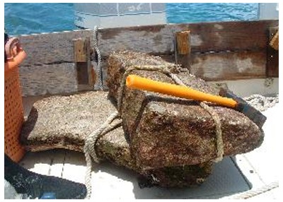
3. That there are no prop stones or leveling blocks under any of the huge blocks. Research in 2005 and 2006 also showed this to be false. Under the watchful cameras of an NBC News film crew making a documentary, we removed numerous rectangular slabs of stone from under the large blocks as well as a large wedge stone, which was used as a leveling block. These were later brought to the surface for examination.
4. That cores from the blocks showed that the stones had been part of the same massive natural formation, specifically that the internal structure of the stones could be traced from one stone to the next. This aspect was not directly investigated by our group.
However, inspection of the actual published reports by the skeptics showed that this was not the actual finding. The initial report clearly indicated that there were great differences between areas of the cores and that they were not, in fact, matched from one stone to the next.
We found that the subsequent reports, all of which were supposedly based on the first one, simply altered the description of the findings to fit the idea that all the stones matched. Two years ago we exposed this hoax.
 5. That all the Bimini Road stones were beachrock, a naturally developing coarse limestone. The idea that all of the literally thousands of stone blocks at Bimini are beachrock comes from a few stone samples, but has been conclusively disproven by a host of researchers.
 However, the geologists claiming that all the stones are beachrock implied that beachrock would not have been used as harbor construction material. In the Mediterranean, dozens of ancient harbor formations have been found and virtually all of them used beachrock to construct breakwaters, quays, and jetties.
In fact, beachrock is the most likely construction material that would have been used. It is at or near the shoreline, easy to cut, and plentiful. The skeptics did not compare any of the ancient harbors in the Mediterranean to the Bimini Road.
In essence, our research showed that the Bimini Road was actually the remains of an ancient harbor with the stone formation serving as a breakwater and quay.
The discovery of dozens of stone anchors there, with obvious rope grooves on them, has verified that there were ancient harbor formations in use.
In 2006, an additional harbor works was found about a mile from the Bimini Road. (It was cleared of sand and exposed by a 2006 hurricane.) Dubbed the "Paradise Point Pier," it appeared to be elevated off the bottom and was constructed from piled stone blocks and also seemed to have numerous "columns" on its surface.
While the ARE's Search For Atlantis Project had expanded well beyond Bimini, there were several areas around Bimini that merited more investigation. The findings are summarized below.
2006-2007 Bimini Expeditions
 In late 2006 and in June 2007, two expeditions were conducted at Bimini. The first was an extensive high-tech project conducted by Bill Donato in November 2006. Both sub-bottom profiling and side-scan sonar were utilized at several areas.
 A final report has yet to be issued. However, Donato has released some of the findings from the side-scan sonar results in deeper water to the west of Bimini.
Donato's project found a line of intriguing bottom structures a few miles west off Bimini at a depth of 100-feet. The computer assisted sonar revealed numerous rectangular features on the bottom.
These formations were all aligned the same way, oriented as if they were small buildings sitting by a shoreline. An immediate effort was made to dive to the features using the gps obtained by the sonar scan images.
However, as this is near the Gulf Stream, there were strong bottom currents that constantly pushed Donato and Krista Brown off the area. After receiving the images from the commercial underwater exploration company he utilized, Donato sent us the relevant images with the gps locations.
Our findings at the site are detailed in the next section. Donato's Bimini exploration also devoted a day to exploring the Paradise Point Pier area. He found numerous stone anchors on the breakwater formation exactly as should be found on an ancient harbor formation.
In addition, we believe that there may be columns there, identical to the columns reported at the inlet between North and South Bimini islands. (The earlier columns found at Bimini were of two types: fluted marble and cement.) There may be many of these columns present at the Paradise Point formation as they appear on our film of the formation.
The importance of these columns is directly related to their use at ancient Mediterranean harbors. For example, the Roman harbor at Cosa had a long breakwater constructed from large slabs of beachrock and other rubble.
Littered on the surface of the breakwater are dozens of cement and fluted marble cylinders identical to those at Bimini. It is not being suggested here that the Bimini formation was a Roman harbor, only that the construction techniques used at Bimini were also employed in the construction of ancient Mediterranean harbors.
 Beyond that link, the identity of the builders remains speculative. The columns appear to have been added to the breakwater top as rubble to rebuild the structure as it deteriorated over time.
 In June 2007, Drs. Greg and Lora Little conducted an expedition to Bimini accompanied by Krista and Eslie Brown. The purpose of the trip was to conduct side-scan sonar of the Bimini Road, the Paradise Point Pier, and the line of stones known as Proctor's Road.
In addition, we planned to investigate the site of Donato's underwater rectangles and a stone formation 7-miles north of Bimini. We have obtained our own side-scan sonar unit, built it into a fully portable model, and utilized it to identify and examine a host of underwater features.
Proctor's Road is a mile-long line of stones to the west of the Bimini Road, near the North Bimini shoreline. Previous research had shown that there were five complete or partial stone circles there, formed from huge stone blocks arranged into circular patterns.
These are perhaps mooring circles, a method of ship mooring utilized at several ancient Mediterranean harbors, including the previously mentioned Cosa harbor. The side-scan sonar was used to measure and analyze the circles.
We were able to identify several of these with the side-scan. In addition, the side-scan sonar was used to obtain a complete image of both the Bimini Road and the Paradise Point Pier. When the images were obtained, sand had covered wide portions of the Bimini Road.
Discovery of Marble "Ruins"
Several years ago the Browns learned of an area about 7-miles north of Bimini, which had some interesting stone blocks on the bottom. Reaching this area, we saw a few dark, coral encrusted beams of stone and several small piles covered with sand. The side-scan sonar revealed that the area was actually widely littered with apparently stone forms hidden under sand.
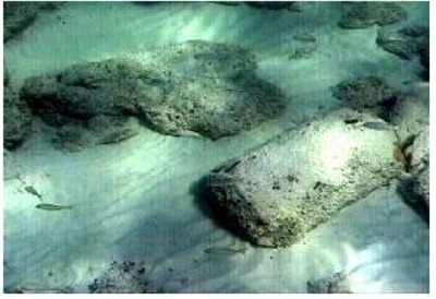
Focusing our efforts on the one small exposed area, we were astonished to see a triangular, well-polished slab of stone that appeared exactly like the apex at the top tip of a roof on a temple.
It was about 7-feet long and its thickness is unknown. The triangular stone was embedded in sand but we were able to confirm that it was at least three feet thick.
After cleaning this stone of sand and debris, a beautiful, somewhat ornate slab was revealed. Several small pieces off the edge of this apex were removed and brought to the surface. It was white marble, gleaming like quartz in the sun.
Several beams, some as long as 15-feet were found, with one end disappearing into the sand. In addition, columns, polished building slabs, and many smaller blocks were found.
Small samples revealed that these were of the same type of white marble. Knowing that the site had been previously known, we then scoured records to see what had been written about it.
 We found that in 1970, Richard Wingate and a group of researchers had investigated the marble. Using an underwater sand blower, Wingate found that the marble was widely scattered and had at least three layers of slabs before it reached the bedrock seabed.
 Under the bottom layer of marble, Wingate found the wooden ribs of an old ship. According to Wingate's group, not far from this site there are massive areas covered with granite slabs, supposedly from two other shipwrecks.
We had previously visited Moselle Shoals, only a few miles away and found shipwrecks and hundreds of granite blocks. Unfortunately, the entire area is literally littered with shipwrecks and such cargo.
In his 1980 book, "Lost Outpost of Atlantis," Wingate related that at some future date an archaeologist would rediscover the marble and wonder what it was. Indeed.
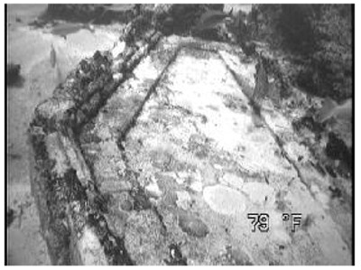
Donato's Underwater Rectangles: Building Foundations? Using the gps obtained from Donato's side scan sonar image, we arrived at the area of the underwater rectangles. We then utilized our own side-scan sonar and found them within 5 minutes.
We used a setting that yields a bottom image 700-feet wide and could see that there were numerous rectangular formations on the bottom lying in what looked like a nearly straight line.
The rectangular forms sat at the top of a 10-foot drop-off, which led to a narrow flat area. Then it descended quickly toward the deep Gulf Stream.
Intrigued, we dropped a lead weight buoy as we passed over one of the larger rectangular forms. We later found that the weight fell directly into the rectangle and, surprisingly, the boat's anchor fell into another one nearby.
The sizes of the rectangular formations vary somewhat with the largest about 15 x 30 feet, however, most of them are smaller, 8 x 10-feet, about the size of small buildings. Their depth (100-feet) is actually just above the sea level at 10,000 B.C. It is known that in 10,000 B.C. the sea levels were about 110-feet lower than today, meaning that these structures were once elevated just above the ancient shoreline.
Eslie and Krista Brown, both of whom are Master Divers, dived the site and took a series of photographs in the cloudy water near the Gulf Stream. When they reached the surface, they reported that the structures were formed out of coral encrusted stone.
The photos revealed that the sides of some of the formations seemed to be made from small stone blocks, some of which sat squarely on top of each other. Several square or rectangular stones appeared to be embedded into the bottom, especially at the corners of the rectangular structures.
In addition, several photos show intriguing artifacts, which could be pots or amphorae. However, only a more detailed investigation can prove the actual identity of the artifacts and the structures.
In sum, the preliminary investigation of these rectangular forms shows that they may well be building foundations, perhaps as old as 12,000-years. Plans are now being made for a more thorough investigation of this site.
Underwater Stone Platform Discovered in Andros Island, Bahamas
A husband-wife research team affiliated with the A.R.E. (Association for Research & Enlightenment) has announced the discovery of a gigantic, three-tiered stone platform lying under 10 feet of water just off northern Andros Island. Drs. Greg and Lora Little, who found the underwater structure, are based in Memphis, TN, and produce a monthly archaeologically-related newsletter for the A.R.E. entitled ‘Ancient Mysteries.’

Other investigators have spotted unusual formations under the shallow coastal waters of Andros, including one in the shape of the cursive letter ‘e’. However, no one had ever visited these sites to determine the nature of the mysterious formations.
During two visits to Andros in February and March, the Littles managed to identify and locate all of the sites during an aerial survey. While Andros is the largest Bahamas island, it is almost completely unexplored and sparsely populated.
Western Andros is virtually uninhabited. Long and difficult trips through mangrove swamps and shallow tidal bays were subsequently made to all of the sites.
The pair found that all of the mysterious underwater formations had natural explanations. But during the March trip, on their last night on the island, an unexpected visitor appeared at their door.
Dino Keller, an experienced diver and former dive operator who is now Vice-President of WAVE-TV, gradually told them about an unusual stone structure he had viewed one time from a boat just after Hurricane Andrew passed the island in 1992. Keller told them “it looked like the Bimini Road, only bigger.”
The Bimini Road is a J-shaped formation of large stones, lying on a sandy bottom a few hundred yards off Bimini Island. Bimini is about 50 miles from Miami and about 100 miles north of Andros. Although still controversial, the Road is often called the ‘Road to Atlantis,’ and many believe it was part of the fabled lost continent.
“We were skeptical,” Lora said, “but we had to look.” So the next morning the Littles went to the general area of Andros where the stones were supposed to be located. Lora videotaped the event while Greg snorkeled out into the ocean.
They eventually found the strange formation about 500 yards offshore. It appeared to be a gigantic, flat-stone platform made by thick, mostly rectangular blocks of stone. But they didn’t have enough time to carefully examine the entire structure. In April the Littles returned to the site for three days, diving and snorkeling while filming and taking measurements.
“It appears to be composed of three flat tiers,” Greg stated. “Each tier is 50 feet wide and rises two feet above the level below it. The bottom tier has well-preserved two-foot-thick rectangular blocks on its front edge.
The blocks are mostly 30- by 25-feet and are lying side by side in rows. The back portion of the 50-foot-wide tier is partially covered with sand and has smaller stone blocks comprising it. Coral is starting to form on portions of it.
Then the second tier starts with another row of 30- by 25-foot stone blocks. Several of these blocks are cracked and broken with seaweed growing between the seams.
The rest of the 50-foot wide tier is partially covered by sand. This leads to the third tier, which is also formed by the same type of huge stones. The highest tier has more damage, and it is partially obscured by sand and rubble.”
While the width of the platform seems to be 150 feet, the length remains unknown. “It appears to be at least 400 yards long,” Greg stated, “but it ends in a huge pile of sand and seaweed. The structure could be natural, and geologists we have contacted think that it is quite special--whatever it is.
“They have suggested that it may be a well-preserved, ancient beach, perhaps 6,000 years old or more. But the tiers increase in height as you move away from the present shoreline toward the ocean. This isn’t what one would usually expect with a beach.
“At first glance it looks manmade, or perhaps at least altered and used by ancient people. But we just don’t know. More study is needed to really determine what it is. It does bear some resemblance to the Bimini Road, but the stones and the structure itself are quite a bit larger.”
The Littles plan to release a video documentary and book on their research at the October 2003 Ancient Mysteries Conference in Virginia Beach.
Contact: ARE 1-800-333-4499
From s8int @ http://www.s8int.com/water34.html and http://www.s8int.com/water14.html
Originally published in Alternate Perceptions Magazine, August 2007
Help This Unique Independent Site Survive
Donate any amount and receive at least one New Illuminati eBook!
Just click in the jar -
For further enlightening information enter a word or phrase into the search box @ New Illuminati or click on any label/tag at the bottom of the page @ http://nexusilluminati.blogspot.com
And see
New Illuminati – http://nexusilluminati.blogspot.com
New Illuminati on Facebook - https://www.facebook.com/the.new.illuminati
New Illuminati Youtube Channel - http://www.youtube.com/user/newilluminati/feed
The Her(m)etic Hermit - http://hermetic.blog.com
The Prince of Centraxis - http://centraxis.blogspot.com (Be Aware! This link leads to implicate & xplicit concepts & images!)
This site is published under Creative Commons Fair Use Copyright (unless an individual item is declared otherwise by copyright holder) – reproduction for non-profit use is permitted & encouraged, if you give attribution to the work & author - and please include a (preferably active) link to the original along with this notice. Feel free to make non-commercial hard (printed) or software copies or mirror sites - you never know how long something will stay glued to the web – but remember attribution! If you like what you see, please send a small but heartfelt donation or leave a comment – and thanks for reading this far…
Live long and prosper!
From the New Illuminati – http://nexusilluminati.blogspot.com
During the Baroque period, which began in the early 17th century, columns once again became a central feature of public buildings and large estates. Columns have been used in Greek architecture since antiquity.
ReplyDelete