Martian Water, Terraces & Life
by Joseph P. Skipper
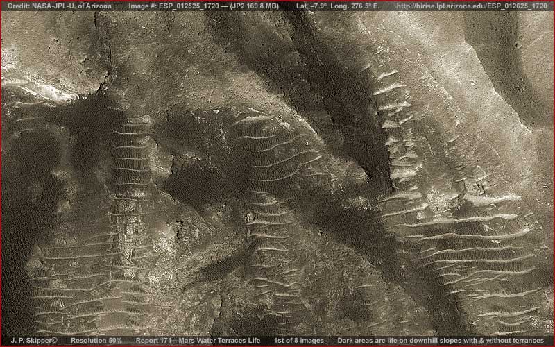
The above image offers a wide-angle context view of a portion of the original image that this evidence comes from. The darker areas you see in the above image are variations of the "Ridge Form" life I have reported on before. Please note that some are occupying terrain with the light color horizontal thin ridge structures like levels of mushrooms on an old tree trunk. On the other hand, others are just occupying large patches of terrain without the horizontal ridge levels.
Let me give you some background information that is very important to understanding what is going on here. This site is within Ius Chasma which is a large steep sided canyon on the southern side of Valles Marineris the largest canyon system in the solar system otherwise known as the Mars great crack. Now Valles Marineris is as deep as 8–10 km or 5–6 miles and that compares to Earth Grand Canyon here in the US of only 1.6 km or 1 mile deep. In other words, in places Valles Marineris is 5–6 times deeper than the Grand Canyon. That's quite a hole in the ground and such a hole guarantees steep slopes on its sides.
Let me give you some background information that is very important to understanding what is going on here. This site is within Ius Chasma which is a large steep sided canyon on the southern side of Valles Marineris the largest canyon system in the solar system otherwise known as the Mars great crack. Now Valles Marineris is as deep as 8–10 km or 5–6 miles and that compares to Earth Grand Canyon here in the US of only 1.6 km or 1 mile deep. In other words, in places Valles Marineris is 5–6 times deeper than the Grand Canyon. That's quite a hole in the ground and such a hole guarantees steep slopes on its sides.
The evidence here is from the huge MRO HiRise ESP_012625_1720 JP2 image. Regardless of its JP2 huge file size at 169.8 MB, the evidence will be fuzzy in the closer views. It's the best I could do with it. As this reporting unfolds, you'll perhaps begin to suspect why there are resolution problems in this image. Even so, it is good enough to understand the basics of what is going on here and I think you'll find it sufficiently interesting.
When you are looking at the above image, north and up is in the top of the image and south and down into the Ius Chasma is in the bottom of the image. This orientation is the same and consistent with all of the images in this report. That is important because in these images, although it may not be visually readily apparent, you will always be looking at slopes that may be from mild in places to very steep in other places in a single image in this rough rocky down sloping terrain.
As I have reported before, ridge form life flourishes best in shallow flowing water and is Martian life that is dependent on that condition. They… orient cooperatively in rows parallel with the water flow. So, even though the water is too shallow and thin to be seen in this distant satellite imaging, you know the water flow is there and its direction by the orientation of the ridge forms. Any intelligence is an unknown factor.
Note the darker ridge forms and the row orientation of up/down between the light coloured equally spaced horizontal ridge layers. These equally spaced layers are terraces no doubt designed to retard water which tends to be too substantial in the steeper slope areas and might otherwise be a waterfall. Since the interval space between the terraced ridge levels in relatively short, note that the darker ridge form life is oriented as usual in rows parallel to the water flow.
However, in those patch areas where this rough terrain isn't as steep, note that the darker ridge forms collect into density without the implementation of the terraces solution to retard water flow. Rather, if you will look closely in the above image and the closer views below, you will see that there is often still a need to retard the water flow and this is accomplished by darker ridge forms forming a tangle or convoluted maze in their orientations. This of course effectively retards water flow by design.
The point of this reporting is that whatever form of water-dependent life this is, it can develop creative design solutions to solving its problems on these steep Chasma slopes. However, planetary geologists working with this space exploration imaging will no doubt tell us that ancient long gone water erosion going down these steep Chasma slopes carved out these formations from layered geological material leaving harder material projecting out and softer material eroded inward. That may sound a little plausible to you? If so, all I can say is look closely at the evidence in the following images and judge for yourself.
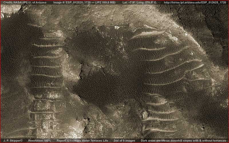
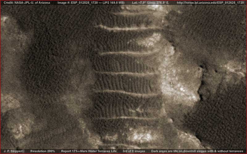
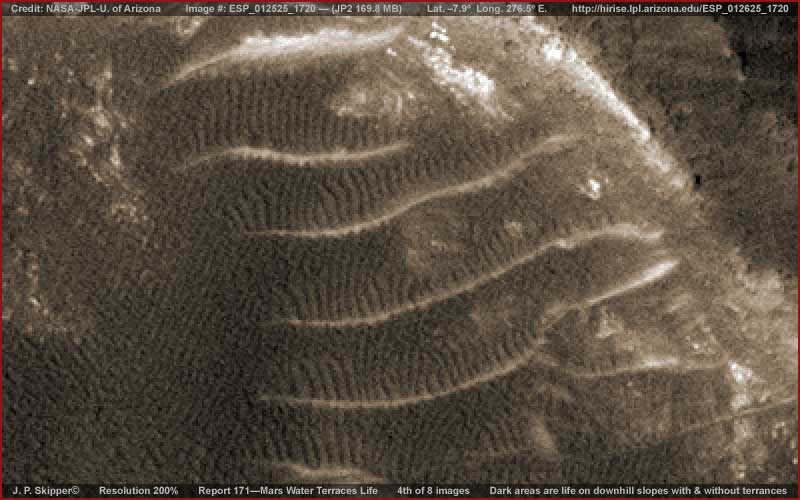
In the above 2nd, 3rd and 4th images, note how the darker ridge forms on the equally spaced terraces always tend to be in parallel rows while those without the terraces tend to be more maze like in their configurations. Although blurry, note the uniformity of the darker coloured evidence. So is this chance geological erosion of layer terrain material or intelligent design typifying life?
Not quite sure what to think? Well the 5th, 6th and 7th images below demonstrate another nearby different section of terrain in this same image strip. Note that here there is an up and down oriented elongated depression and precisely filled, much more pronounced huge terraces that even have the visual impression of being cantilevered to some degree with some appearing to cast shadows on the terrace below that they overhang. Note that the upper surface of each largest terrace is always densely packed with something upright and in high density.
Not quite sure what to think? Well the 5th, 6th and 7th images below demonstrate another nearby different section of terrain in this same image strip. Note that here there is an up and down oriented elongated depression and precisely filled, much more pronounced huge terraces that even have the visual impression of being cantilevered to some degree with some appearing to cast shadows on the terrace below that they overhang. Note that the upper surface of each largest terrace is always densely packed with something upright and in high density.
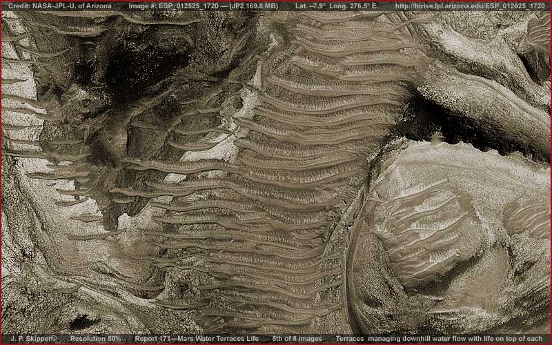
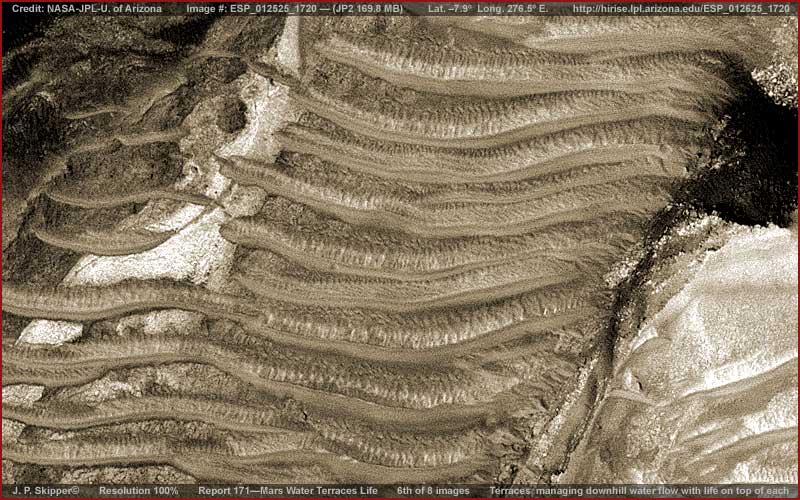
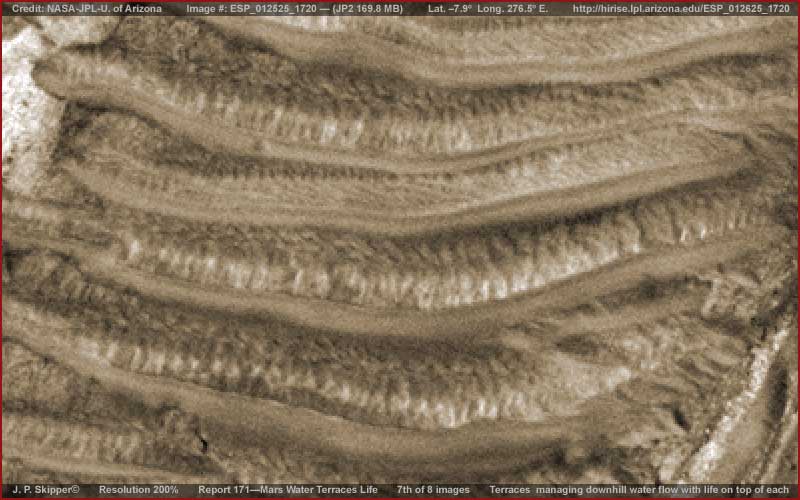
Unfortunately, the blurry resolution of the original doesn't allow us a better look at the smaller upright densely packed evidence on the top side of each terrace. So we can't determine, for example, if these might be upright structures like dwellings or some giant life form developing multiple layers along the depression water flow route like some form of mushroom colony life with the upright structures acting as filters. On the other hand, for me it is a clear indication of life of some kind and not inanimate geology.
There is just too much uniformity from level to level consistent with adaptive life of the some unknown kind here as opposed to chance geological erosion. However, either way, such analysis is based on the presence of water either currently enabling life or in ancient times eroding geological layers. So, if life is to be considered, is there any evidence of current surface water in this location? As it turns out, there is and the next and last image below defines it.
There is just too much uniformity from level to level consistent with adaptive life of the some unknown kind here as opposed to chance geological erosion. However, either way, such analysis is based on the presence of water either currently enabling life or in ancient times eroding geological layers. So, if life is to be considered, is there any evidence of current surface water in this location? As it turns out, there is and the next and last image below defines it.
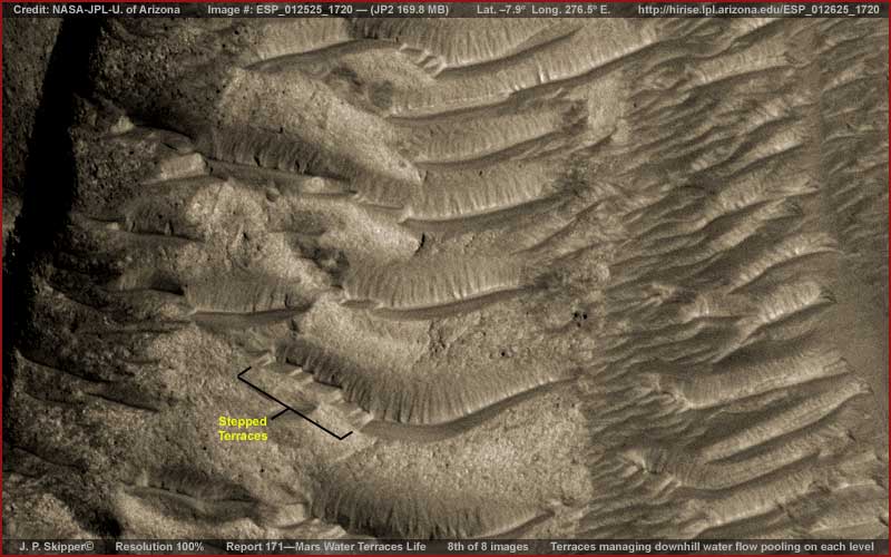
The above eighth image demonstrates the presence of surface water very nearby in the same image strip. What you're looking at is a shallow depression with crisscrossing forms in it and shallow water among those terracing forms. Water comes into this up and down oriented depression mostly from the water flow eroded land forms on the right and works its way down through and around these terracing forms.
Note that I have pointed out some smaller stepped terraces labelled with yellow text. On this particular terrace, water from the terrace above obviously flows around the left end and then back to the right down the steps I've pointed out that slow the water flow. These are the most visually obvious of such steps in this image but there are others if you will look close.
I have no idea whether these terraces are purely land forms that they look like here or whether they represent the beginnings of the same type of mature terraces we see in the 5th, 6th and 7th images. At this point I'm not concerned with that question so much as the fact of this evidence of current water presence in this same image with all the implications that this has for enabling life.
Obviously surface water is consistently flowing down these Chasma slopes and with canyons in the great crack being as much as 8-10 km or 5-6 miles deep, regardless of any prejudices about Mars’ dry conditions, this is to be expected and should come as no surprise. The real surprise would be if there was no water at all coming down these slopes. Where there is water there is life and life usually finds a way, especially when it has time to adapt.
You see, these things, although they may seem a bit strange to some at first blush due to unfamiliarity, do not require rocket science mental acuity, only decent eyesight and some common sense unfettered by close mindedness. For the most part, things are impossible only in the psychology of perception while the real world moves on doing its thing.
DOCUMENTATION
http://hirise.lpl.arizona.edu/ESP_012625_1720: This links takes you to the official MRO HiRise ESP_012625_1720 science data image. Note that I developed this report's evidence from the JP2 169.8 MB image which requires the free IAS Viewer and you'll have to use that to get the same quality results.
Joseph P. Skipper, Investigator
J. P. Skipper can be contacted at: jskipper@marsanomalyresearch.comFrom Mars Anomaly Research @ http://www.marsanomalyresearch.com/evidence-reports/2009/171/water-terraces-life.htm
For more information about Martian anomalies see http://nexusilluminati.blogspot.com/search/label/mars
For further enlightening information enter a word or phrase into the search box @ New Illuminati or click on any label/tag at the bottom of the page @ http://nexusilluminati.blogspot.com
And see
The Her(m)etic Hermit - http://hermetic.blog.com
New Illuminati – http://nexusilluminati.blogspot.com
New Illuminati on Facebook - http://www.facebook.com/pages/New-Illuminati/320674219559
This material is published under Creative Commons Fair Use Copyright (unless an individual item is declared otherwise by copyright holder) – reproduction for non-profit use is permitted & encouraged, if you give attribution to the work & author - and please include a (preferably active) link to the original along with this notice. Feel free to make non-commercial hard (printed) or software copies or mirror sites - you never know how long something will stay glued to the web – but remember attribution! If you like what you see, please send a tiny donation or leave a comment – and thanks for reading this far…
From the New Illuminati – http://nexusilluminati.blogspot.com
you are lost in spacetime because you have not figured out motion and POV yet
ReplyDeleteoops I forgot to select 'notify me'
ReplyDeleteplease do
we can discuss this here
http://at37.wordpress.com/2013/11/24/137-the-key-to-the-collective-unconscious-and-the-temple-of-man/