What Lies Beneath Stonehenge?
A groundbreaking survey of the
site has turned up tantalizing new clues to what really went on there -
Fifteen previously unknown monuments discovered underground in Stonehenge landscape
Gaffney’s latest research effort, the Stonehenge Hidden Landscapes Project, is a four-year collaboration between a British team and the Ludwig Boltzmann Institute for Archaeological Prospection and Virtual Archaeology in Austria that has produced the first detailed underground survey of the area surrounding Stonehenge, totaling more than four square miles. The results are astonishing. The researchers have found buried evidence of more than 15 previously unknown or poorly understood late Neolithic monuments: henges, barrows, segmented ditches, pits.
To Gaffney, these findings suggest a scale of activity around Stonehenge far beyond what was previously suspected. “There was sort of this idea that Stonehenge sat in the middle and around it was effectively an area where people were probably excluded,” Gaffney told me, “a ring of the dead around a special area—to which few people might ever have been admitted....Perhaps there were priests, big men, whatever they were, inside Stonehenge having processions up the Avenue, doing...something extremely mysterious. Of course that sort of analysis depends on not knowing what’s actually in the area around Stonehenge itself. It was terra incognita, really.”

The huge bluestones each weigh between four and eight tons and were brought to the site from North Wales, 170 miles away. (Photo by Henrik Knudsen, with thanks to English Heritage)


Nighttime only enhances the mystery of Stonehenge (above, a pair of enormous trilithons). Was it a temple? A graveyard? A healing place? (Photo by Henrik Knudsen, with thanks to English Heritage)
Nobody has yet put a spade in the ground to verify the new findings, which were painstakingly gathered by geophysicists and others wielding magnetometers and ground-penetrating radars that scan the ground to detect structures and objects several yards below the surface. But Gaffney has no doubt of the work’s value. “This is among the most important landscapes, and probably the most studied landscape, in the world,” he says. “And the area has been absolutely transformed by this survey. Won’t be the same again.”

The joys and frustrations of all archaeological study—perhaps all historical inquiry—come into particularly sharp relief at Stonehenge. Even to the most casual observer, the monument is deeply significant. Those vast stones, standing in concentric rings in the middle of a basin on Salisbury Plain, carefully placed by who-knows-who thousands of years ago, must mean something. But nobody can tell us what. Not exactly. The clues that remain will always prove insufficient to our curiosity. Each archaeological advance yields more questions, and more theories to be tested. Our ignorance shrinks by fractions. What we know is always dwarfed by what we can never know.
Take the big question: Was Stonehenge predominantly a temple, a parliament or a graveyard? Was it a healing ground? We don’t know, for sure. We know that people were buried there, and that the stones are aligned in astronomically important ways. We also understand, because of the chemical composition of animal bones found nearby and the provenance of the stones, that people traveled hundreds of miles to visit Stonehenge. But we cannot say, with certainty, why.

Try a simpler question: How did the bluestones, which weigh between four and eight tons apiece, arrive at the site, nearly 5,000 years ago, from 170 miles away in North Wales? Land or sea? Both alternatives explode with possibilities, and nobody has an impregnable theory. Mike Parker Pearson of University College London is working on a new idea that the bluestones might have been lifted onto huge wooden lattices and carried by dozens of men to the site. But it’s just a theory. We can’t know, definitively. We can only have better-informed questions.
The ineffability of Stonehenge has not dulled our appetite. The site has long proved irresistible to diggers. In 1620, the Duke of Buckingham had his men excavate right in the center of the monument. Although they did not know it at the time, they dug on the site of a prehistoric pit. Buckingham’s men found skulls of cattle “and other beasts” and large quantities of “burnt coals or charcoals”—but no treasure, as they had hoped.
In the 19th century, “barrow-digging,” or the excavation of prehistoric monuments and burial hills, was a popular pastime among the landed gentry. In 1839, a naval officer named Captain Beamish dug out an estimated 400 cubic feet of soil from the northeast of the Altar Stone at Stonehenge. As Parker Pearson notes in his book Stonehenge, Beamish’s “big hole was probably the final blow for any prehistoric features...that once lay at Stonehenge’s center.”


Work at Stonehenge became less invasive. In 1952, Willard Libby—the American chemist and later a Nobel Prize winner—used his new radiocarbon dating technique on a piece of charcoal from a pit within Stonehenge to date the monument to 1848 B.C., give or take 275 years. That date has since been refined several times. The prevailing opinion is that the first stones were erected on the site around 2600 B.C. (although the building of Stonehenge was carried out over a millennium, and there were centuries of ritual activity at the site before the stones were in place).
In 2003, Parker Pearson conducted his own survey, concentrating on the nearby settlement at Durrington Walls and the area between there and the River Avon. Based on huts, tools and animal bones he uncovered, he concluded that Durrington Walls likely housed the workers who built Stonehenge. Based on an analysis of human remains he later excavated from Stonehenge, he also surmised that, far from being a site of quotidian religious activity, Stonehenge served as a cemetery–a “place for the dead.”
The Stonehenge Hidden Landscapes Project is different from everything that came before it. When Gaffney and his team started their work, they were less interested in theories than in data. To that end, they concentrated on taking what amounts to a three-dimensional and yards-deep photograph of the entire landscape. “The perceived wisdom was driven by the monuments we knew about,” says Gaffney. “We’ve put in the data between the monuments.”

The Gaffney brothers’ interest in new technologies that were becoming available to archaeologists led them to the first GPS-guided magnetometer systems. A magnetometer has sensors that allow a geophysicist to see evidence of historic building, and even ancient ditch-digging, beneath the soil by mapping variations in the earth’s magnetic field. The GPS-guided versions were able to pinpoint some of those discoveries to within one centimeter. The Gaffneys believed that Stonehenge scholarship needed a massive magnetometer- and radar-led survey of the whole site. “We just didn’t know if anything’s there,” Vince Gaffney recalled. “So we’re constructing various hypotheses on the basis of something we don’t know.”
Around the same time, an Austrian archaeologist named Wolfgang Neubauer, now of the Boltzmann Institute, was hoping to conduct large-scale projects all over Europe using tools including GPS magnetometers and ground-penetrating radar. Neubauer’s team had also developed software to process the 40 or 50 gigabytes of raw data that these instruments could create in a day. Suddenly, instead of waiting weeks or months to see what the machines had found, it was possible to cover several acres with magnetometers and radar in a day and to display that information on a screen almost instantaneously.
One of the areas Neubauer wanted to scan was Stonehenge, and in the spring of 2009 he contacted Vince Gaffney. A few months later, the Boltzmann Institute and the University of Birmingham—plus several other British and European universities, museums and companies that contributed expertise and resources—began their collaboration at Stonehenge.
Their first days on site, Gaffney recalled, were “like a geophysical circus has come to town.” Tractors pushed the ground-penetrating radars, which looked like high-powered lawn mowers. All-terrain vehicles dragged the magnetometer sensors on long strings. Delicate instruments covering hard, uneven ground kept mechanics and technicians busy. “I have seen one of our magnetometers shear clear apart in front of me,” said Gaffney. “It was back in service the next day.” In all, the fieldwork took about 120 days, spread over four years.

In a multimedia room at the University of Birmingham there was a vast touch screen, six feet by nine, on which a new map of the Stonehenge landscape appeared. Gaffney pointed out the key features.
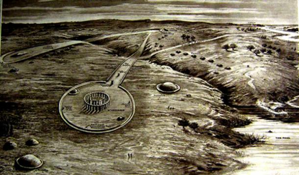
There was Stonehenge itself, marked by the familiar circles. To the north was the long, thin strip called the Stonehenge Cursus or the Greater Cursus, which was demarcated by ditches, and ran east to west for nearly two miles. (The Cursus was given its name by the antiquarian William Stukeley in the 18th century because it looked like an ancient Roman race course. Its construction predates the first building work at Stonehenge by several hundred years.) Gaffney also pointed out the Cursus Barrows—hillocks containing mass human graves—just south of the Cursus itself, and King Barrow Ridge to the east.
Scattered all over the map were blotches of black: features without names. These were new finds, including the more than 15 possible new or poorly understood Neolithic monuments. Gaffney emphasized possible, acknowledging that it will require digging—“the testimony of the spade”—to discover precisely what was there.
Standing in front of this constellation of evidence, he seemed unable to decide where to start, like a child at the Christmas tree. “These are little henge monuments,” he said, touching the screen to highlight a group of black smudges. “Nice little entrance there, and a ditch. These things we know nothing about.”
He saved his greatest enthusiasm for the discoveries that had been made in the Cursus. This feature, said Gaffney, had always been thought of as a “bloody great barrier to the north of Stonehenge.” Nobody knew quite what it was for. Because the Cursus runs east to west, archaeologists have always believed that its presence owes something to the passage of the sun. The monument must be significant: It was dug in the fourth millennium B.C. using antler picks—hundreds of thousands of man-hours went into its construction.
The Hidden Landscapes Project’s instruments discovered several new clues. First of all, they found gaps in the ditch, in particular a very large break in the northern side, to allow people to enter and exit the Cursus. Now, instead of seeing the Cursus exclusively as a monument that encouraged movement along the path of the sun, east to west, Gaffney began to consider these gaps as “channels through the landscape” to guide the movement of people north to south.
A bigger discovery, Gaffney says, was a “bloody huge” pit about five yards in diameter at the eastern end of the Cursus. Today it lies buried at least three feet below the surface of the ground. Such a pit was much too large for a practical use—for instance, burying trash—because of the labor involved in digging it. In the archaeologists’ minds it could only have ritual implications, as “a marker of some kind,” Gaffney said. What’s more, if you drew a straight line between the pit and the heelstone at Stonehenge, it ran directly along the final section of the Avenue, on the path of the sunrise on the summer solstice.
“We thought, That’s a bit of a coincidence!” Gaffney recalled. “That was the point at which we thought, What’s at the other end? And there’s another pit! Two pits, marking the midsummer sunrise and the midsummer solstice, set within a monument that’s meant to be something to do with the passage of the sun.”
With his hands passing over the map, Gaffney showed how—on the longest days of the year—the pits formed a triangle with Stonehenge marking sunrise and sunset.
“Nobody had ever seen these pits before,” he continued. “But they link the area of Stonehenge with the Cursus directly. Either these things have been put inside the Cursus to mark these points, or the Cursus has been wrapped around them.”
What was so interesting about the Cursus pits was that they told a story about the landscape. The “sunrise” pit was visible from Stonehenge, but the “sunset” pit was not—it was nestled behind a ridge, and could have been seen only if there had been fire and smoke coming from it. (At some point the pits will have to be excavated for evidence of such activity.) These discoveries fed into a larger understanding of Stonehenge as “diachronic”—operating in light and dark, sunrise and sunset, day and night.
“The point I think we’re coming to,” said Gaffney, “is that increasingly we can see the area around Stonehenge as providing extensive evidence for complex liturgical movement—which we can now understand, largely because we know where things are.”
Parker Pearson, for his part, takes a cautious view of the new research. “Until you dig holes, you just don’t know what you’ve got,” he told me in his office at University College London. “What date it is, how significant it is. [There are] extraordinary new features coming up, and we’re thinking well, what are they?”
To be sure, he said the data from the Hidden Landscapes Project “backs up the pattern we’ve already been seeing for some years. We have an excessive number of solstice-aligned monuments in that landscape. Nowhere in the rest of Europe comes even close.” He added, “This is fantastic stuff that’s been done, and it’s raised a whole series of new questions,” he said. “It’s going to take years.”

The clouds shifted in front of the sun, dappling the landscape with shadow. Gaffney and I were walking the Avenue, 300 yards or so from Stonehenge, and in the distance a string of barrows gleamed like opals. Although he acknowledged the fallibility of all archaeological projection (“In the end,” he said, “we are all wrong”), his work has led him to a new interpretation of how Stonehenge was used.
Gaffney’s idea was not to focus on Stonehenge itself, but on “processionality” within the whole landscape. He imagined people moving around the area like Roman Catholics processing through the Stations of the Cross. He recalled an Easter Friday ritual he saw in Croatia, in which a “bloke with a cross” led fellow barefoot celebrants on a miles-long trip. In Gaffney’s view, the building of the great stone circle was a “monumentalizing” of a similar, if heathen, procession.
As we walked downhill through the fields, Gaffney stopped from time to time to point out the hillocks in which “the illustrious dead” were buried. He also noted how the Avenue was not a straight line between the Avon and Stonehenge, but rather a series of tacks that brought the visitor to the Stonehenge site in a “theatrical” way, along the line of sunrise on the summer solstice.
He thrust himself into the mind of a Bronze Age visitor to the site. “You will have seen nothing like it,” he said. “It would have been massively impressive.” Soon we descended into a valley called Stonehenge Bottom, only a hundred yards or so from the great stones. “They’re disappearing....Watch, just watch!” he said.
Within a few yards, the monument became invisible. When you picture Stonehenge in your mind’s eye, you imagine the concentric rings of vast stones standing in a desolate open landscape, visible for miles around. But now, here we were, a hundred yards away, and the thing had gone.
We stood in a field, watched by some lethargic cows, and savored the strangeness of the moment. Then, as we stepped uphill, Stonehenge re-emerged on the horizon. It happened fast. The lintels, then the great sarsens, then the smaller bluestones were suddenly before us.
Gaffney’s voice lifted. He spoke about Jerusalem Syndrome: the feeling of intense emotion experienced by pilgrims on their first sighting of the Holy City. In the prehistoric world, there was no conception of God as he was understood by the later Abrahamic faiths. But, said Gaffney, as Stonehenge reappeared before us, “whatever the ancient version of Jerusalem Syndrome is, that’s what you’re feeling now.”
From The Smithsonian @ http://www.smithsonianmag.com/history/what-lies-beneath-Stonehenge-180952437/?all&no-ist
- Scroll down through ‘Older Posts’ at the end of each section
Hope you like this
not for profit site -
It takes hours of work every day by
a genuinely incapacitated invalid to maintain, write, edit, research,
illustrate and publish this website from a tiny cabin in a remote forest
Like what we do? Please give enough
for a meal if you can -
Contribute any amount and receive at
least one New Illuminati eBook!
Please click below -
Xtra Image – http://www.themodernantiquarian.com/post/82412/images/stonehenge_and_its_environs.html
For further enlightening
information enter a word or phrase into the random synchronistic search box @
the top left of http://nexusilluminati.blogspot.com
And see
New Illuminati – http://nexusilluminati.blogspot.com
New Illuminati on Facebook - https://www.facebook.com/the.new.illuminati
New Illuminati Youtube Channel - http://www.youtube.com/user/newilluminati/feed
New Illuminati on Google+ @ https://plus.google.com/115562482213600937809/posts
New Illuminati on Twitter @ www.twitter.com/new_illuminati
New Illuminations –Art(icles) by
R. Ayana @ http://newilluminations.blogspot.com
The Her(m)etic Hermit - http://hermetic.blog.com
The Prince of Centraxis - http://centraxis.blogspot.com (Be
Aware! This link leads to implicate & xplicit concepts & images!)
DISGRUNTLED SITE ADMINS PLEASE NOTE –
We provide a live link to your original material on your site (and
links via social networking services) - which raises your ranking on search
engines and helps spread your info further! This site is
published under Creative Commons Fair Use Copyright (unless an individual
article or other item is declared otherwise by the copyright holder). Reproduction
for non-profit use is permitted & encouraged, - if you give attribution to the work &
author. Please include a (preferably active) link to the original (along with
this or a similar notice).
Feel free to make non-commercial hard (printed) or software copies or
mirror sites - you never know how long something will stay glued to the web –
but remember attribution!
If you like what you see, please send a donation (no amount is too
small or too large) or leave a comment – and thanks for reading this far…
Live long and prosper! Together we can create the best of all possible
worlds…
From the New Illuminati – http://nexusilluminati.blogspot.com


