Earth’s Magnetic Field Shifting Now
Superstorms Coming...

Earth's
magnetic field showing signs of significant weakening
The first set of high-resolution results from ESA’s
three-satellite Swarm constellation reveals the most recent changes in the magnetic field that protects us
from cosmic radiation and charged particles that bombard Earth.
Magnetic field is in
a permanent state of flux. Magnetic north wanders, and every
few hundred thousand years the polarity flips so that a compass would
point south instead of north. Moreover, the strength of the magnetic field
constantly changes – and it is currently showing signs of significant
weakening. (ESA)
Measurements made by
Swarm over the past six months confirm the general trend of the field’s
weakening, with the most dramatic declines over the Western
Hemisphere. But in other areas, such as the southern Indian Ocean, the
magnetic field has strengthened since January.
The field is particularly
weak over the South Atlantic Ocean – known as the South Atlantic Anomaly
and the latest measurements confirm the movement of magnetic North towards
Siberia.
The weak field has
indirectly caused many temporary satellite ‘hiccups’ (called Single Event
Upsets) as the satellites are exposed to strong radiation over this area.
(ESA)
This animation shows
changes in Earth’s magnetic field from January to June 2014 as measured by
ESA’s Swarm trio of satellites:
 ‘Snapshot’ of the main magnetic field at Earth’s surface
as of June 2014 based on Swarm data. The measurements are dominated by the
magnetic contribution from Earth’s core (about 95%) while the contributions
from other sources (the mantle, crust, oceans, ionosphere and magnetosphere)
make up the rest. Red represents areas where the magnetic field is stronger,
while blues show areas where it is weaker. image copyright: ESA/DTU Space
‘Snapshot’ of the main magnetic field at Earth’s surface
as of June 2014 based on Swarm data. The measurements are dominated by the
magnetic contribution from Earth’s core (about 95%) while the contributions
from other sources (the mantle, crust, oceans, ionosphere and magnetosphere)
make up the rest. Red represents areas where the magnetic field is stronger,
while blues show areas where it is weaker. image copyright: ESA/DTU Space
 Swarm is ESA's first Earth observation constellation of
satellites. The three identical satellites are launched together on one
rocket. Two satellites orbit almost side-by-side at the same altitude –
initially at about 460 km, descending to around 300 km over the lifetime of the
mission. The third satellite is in a higher orbit of 530 km and at a slightly
different inclination. The satellites’ orbits drift, resulting in the upper
satellite crossing the path of the lower two at an angle of 90° in the third
year of operations.
Swarm is ESA's first Earth observation constellation of
satellites. The three identical satellites are launched together on one
rocket. Two satellites orbit almost side-by-side at the same altitude –
initially at about 460 km, descending to around 300 km over the lifetime of the
mission. The third satellite is in a higher orbit of 530 km and at a slightly
different inclination. The satellites’ orbits drift, resulting in the upper
satellite crossing the path of the lower two at an angle of 90° in the third
year of operations.
The different orbits along with satellites’ various
instruments optimise the sampling in space and time, distinguishing between the
effects of different sources and strengths of magnetism. Image
copyright: ESA/AOES Medialab
Swarm
was launched in November 2013 and is providing unprecedented insights into
the complex workings of Earth’s magnetic field. The objective of the Swarm
mission is to provide the best-ever survey of the geomagnetic field and its
temporal evolution as well as the electric field in the atmosphere using a
constellation of 3 identical satellites carrying sophisticated magnetometers
and electric field instruments.
Its first results
were presented today, June 19th, at the ‘Third Swarm Science Meeting’ in
Copenhagen, Denmark.
“These initial results
demonstrate the excellent performance of Swarm,” said Rune Floberghagen, ESA’s
Swarm Mission Manager. “With unprecedented resolution, the data also
exhibit Swarm’s capability to map fine-scale features of the magnetic field.”
Over the coming months,
scientists will analyse the data to unravel the magnetic contributions from
other sources, namely the mantle, crust, oceans, ionosphere and magnetosphere.
This will provide new
insight into many natural processes, from those occurring deep inside our planet
to space weather triggered by solar activity. In turn, this information will
yield a better understanding of why the magnetic field is weakening.
From The Watchers @ http://thewatchers.adorraeli.com/2014/06/19/earth-s-magnetic-field-showing-signs-of-significant-weakening
Earth's Magnetic Field Is Weakening 10 Times Faster Now
by Kelly Dickerson
Earth's
magnetic field, which protects the planet from huge blasts of deadly solar
radiationhas been
weakening over the past six months, according to data collected by a European
Space Agency (ESA) satellite array called Swarm.
The biggest weak spots in the magnetic field — which extends 370,000 miles (600,000 kilometers) above the planet's surface — have sprung up over the Western Hemisphere, while the field has strengthened over areas like the southern Indian Ocean, according to the magnetometers onboard the Swarm satellites — three separate satellites floating in tandem.
The scientists who conducted the study are still unsure why the magnetic field is weakening, but one likely reason is that Earth's magnetic poles are getting ready to flip, said Rune Floberghagen, the ESA's Swarm mission manager. In fact, the data suggest magnetic north is moving toward Siberia.
"Such a flip is not instantaneous, but would take many hundred if not a few thousand years," Floberghagen told Live Science. "They have happened many times in the past."[50 Amazing Facts About Planet Earth]
Scientists already know that magnetic north shifts. Once every few hundred thousand years the magnetic poles flip so that a compass would point south instead of north. While changes in magnetic field strength are part of this normal flipping cycle, data from Swarm have shown the field is starting to weaken faster than in the past. Previously, researchers estimated the field was weakening about 5 percent per century, but the new data revealed the field is actually weakening at 5 percent per decade, or 10 times faster than thought. As such, rather than the full flip occurring in about 2,000 years, as was predicted, the new data suggest it could happen sooner.
Floberghagen hopes that more data from Swarm will shed light on why the field is weakening faster now.
Still, there is no evidence that a weakened magnetic field would result in a doomsday for Earth. During past polarity flips there were no mass extinctions or evidence of radiation damage. Researchers think power grids and communication systems would be most at risk.

Earth's magnetic field acts like a giant invisible bubble that shields the planet from the dangerous cosmic radiation spewing from the sun in the form of solar winds. The field exists because Earth has a giant ball of iron at its core surrounded by an outer layer of molten metal. Changes in the core's temperature and Earth's rotation boil and swirl the liquid metal around in the outer core, creating magnetic field lines.
The movement of the molten metal is why some areas of the magnetic field strengthen while others weaken, Florberghagen said. When the boiling in one area of the outer core slows down, fewer currents of charged particles are released, and the magnetic field over the surface weakens.
"The flow of the liquid outer core almost pulls the magnetic field around with it," Floberghagen said. "So, a field weakening over the American continent would mean that the flow in the outer core below America is slowing down."
The Swarm satellites not only pick up signals coming from the Earth's magnetic field, but also from its core, mantle, crust and oceans. Scientists at the ESA hope to use the data to make navigation systems that rely on the magnetic field, such as aircraft instruments, more accurate, improve earthquake predictions and pinpoint areas below the planet's surface that are rich in natural resources. Scientists think fluctuations in the magnetic field could help identify where continental plates are shifting and help predict earthquakes.
These first results from Swarm were presented at the Third Swarm Science Meeting in Denmark on June 19.
Follow Kelly Dickerson on Twitter. Follow us @livescience, Facebook & Google+. Original article on Live Science @ http://www.livescience.com/46694-magnetic-field-weakens.html
[New Illuminati comments: While the standard view of the driving force behind our planet's magnetic field is clearly enunciated above it isn't a model to which we subscribe.]
Plausible and Inevitable: The ARkStorm Scenario
 In California, “The Big
One” is usually associated with a major earthquake that would severely disrupt the
way of life for millions living next to or near the San Andreas Fault.
In California, “The Big
One” is usually associated with a major earthquake that would severely disrupt the
way of life for millions living next to or near the San Andreas Fault.Now, scientists with the U.S. Geological Survey (USGS) have come forward with another “Big One” scenario, but instead of the ground shaking, in this case it would be underwater in many parts of the state after weeks of relentless rain. The exercise has a catchy name, “ARkStorm,” and has reminded people that California has a history of flooding and that the next big storm could be just around the corner. ARkStorm stands for an atmospheric river (“AR”) that carries precipitation levels expected to occur once every 1,000 years (“k”). The project is intended “to elevate the visibility of the very real threats to human life, property and ecosystems posed by extreme storms on the West Coast,” according to USGS. “For many people, the storms of 1969, 1986 and 1997 mean nothing,” said Dale Cox, chief of staff for the USGS Pacific Southwest Region who managed the project. “That's why we called it ARkStorm.
We needed to scale the size of the storm.” In an ARkStorm scenario, a month's worth of rain dumps as much as 10 feet of water on the state, fed by a conveyor belt of tropical moisture. In addition to the expected damages (which include interruption of water conveyance), the storm has several public policy implications, most notable emergency preparedness. But there is also the “core issue” of “whether to pay now to mitigate, or pay a lot more later for recovery,” according to USGS.
ARkStorm rainfall totals in some places would “overwhelm” the flood protection system in many areas, USGS says. The Central Valley would experience a “hypothetical” flood 300 miles long and 20 miles wide, while Orange County, Los Angeles County, San Diego and the Bay Area would all be hit with serious flooding. “Both because of its large geographic size and the state's economic interdependencies, an ARkStorm would affect all California counties and all economic sectors,” the report, Overview of the ARkStorm Scenario, says.
The deluge of water would cause hundreds of landslides and property damage would run in the hundreds of billions of dollars. Coupled with factors such as agricultural losses, the costs of restoring pipelines and business interruptions costs, ARkStorm “could cost on the order of $725 billion, which is nearly three times the loss deemed to be realistic … for a severe Southern California earthquake, an event with roughly the same annual occurrence probability.”
The timing of the ARkStorm release was fortuitous. In December 2010, a series of storms slammed into California, hitting the southern part of the state especially hard and remind¬ing people about how quickly conditions can deteriorate. “An ARkStorm is plausible, perhaps inevitable,” the report says. “There may be no pattern that forces the storms to occur with clockwork regularity, so such an event could occur in any year.”
The image of a flood of biblical proportions is not unintentional, as the scale of anticipated precipitation would be on a scale previously unseen. California flooding references often point to the winter of 1861 when the city of Sacramento was 10 feet underwater.
USGS says a repeat of a storm that size is certainly capable of happening, just as the 1,000-year events in Pakistan last year and Australia in January. What's surprising, experts say, is that California isn't walloped by such super soakers more often. Until the next big storm arrives, the authors of ARkStorm say there is time for planners to consider the level of readiness and whether further investment is necessary.
“Although enhancing state flood protection is very costly; not doing so may be even more so,” the report says. “Enhancing urban sections of the state flood protection system to 500-year levels could realistically cost $10s of billions. Not doing so could realistically cost $100s of billions when such a storm occurs.”
Critics say a major flood is a crisis waiting to happen, because of the state's inability to come to grips with the nature of the threat. “The state has some of the most flood-prone land in the nation, much of which has been urbanized,” according to Managing California's Water: From Conflict to Reconciliation, a February 2011 re¬port by the Public Policy Institute of California (PPIC). “California faces increasing flood management challenges, with an extensive legacy of short-sighted flood infrastructure decisions, growing human and economic activity in floodplains, growing state liability for flooding, diminished long-term federal and state funding, continued separation of land and flood management, and climate change.”
PPIC calls for a new direction in flood management that recognizes the risk posed to communities rather than concentrating on building stronger levees to protect existing and prospective development.
“Flood management in California has had a historical tendency to over-invest in a few tools to increase flood protection, without regard to flood vulnerability,” the PPIC report says. “The unintended consequence of these investments is often an increased, rather than a decreased, flood risk.”
PPIC's warning touches upon a familiar problem - urban development in floodplains. Pal Hegedus, vice president of RBF Consulting and chair of the Floodplain Management Association, said there is an “inherent conflict” with the concept of having a short commute and “smart cities” developed within the floodplain at the same time there is a flood risk to these urban areas. Ultimately, a workable middle ground has to be found.
“We can't all move out to the foothills,” he said. “It's a very complex issue.”
In 2005, Hurricane Katrina in New Orleans vividly demonstrated the destruction that comes with levee failure. Cognizant of the risk facing the Central Valley, lawmakers in 2007 required new development to surpass the federal flood protection standard by requiring a 200-year level of protection.
In 2012, state officials are scheduled to approve the Central Valley Flood Protection Plan for the Sacramento-San Joaquin Valley that aims to provide 200-year flood protection for urban areas (The level of flood protection, i.e. 50-year, 100-year, reflects the probability of a particular-sized storm occurring in a given year. A 100-year storm has a 1 percent chance of occurring each year.) Implementing language for the plan in the California Water Code notes that despite structural improvements, flood risks will remain for those living in the Central Valley floodplains and that “making those flood risks more apparent will help ensure that Californians make careful choices when deciding whether to build homes or live in Central Valley floodplains, and if so, whether to prepare for flooding or maintain flood insurance.”
The difference between preparing for a 200-year storm and the epic event described by USGS is not insignificant and calls into question what can reasonably be defended against. ARkStorm planners acknowledge that “California flood protection is not designed for an ARkStorm-like event.” While many improvements have been made, “the state flood protection system is not perfect.”
State officials acknowledge only a certain level of safety is attainable.
“The storm they are talking about is quite a bit bigger than we designed for our flood control facilities,” said Jay Punia, executive officer of the Central Valley Flood Protection Board. “It's a fact that due to economic considerations, we can't provide ultimate protection for such a large event.”
From Water Education @ http://www.watereducation.org/doc.asp?id=2075
Overview of the ARkStorm Scenario
By Keith Porter, Anne Wein, Charles Alpers, Allan Baez, Patrick Barnard, James Carter, Alessandra Corsi, James Costner, Dale Cox, Tapash Das, Michael Dettinger, James Done, Charles Eadie, Marcia Eymann, Justin Ferris, Prasad Gunturi, Mimi Hughes, Robert Jarrett, Laurie Johnson, Hanh Dam Le-Griffin, David Mitchell, Suzette Morman, Paul Neiman, Anna Olsen, Suzanne Perry, Geoffrey Plumlee, Martin Ralph, David Reynolds, Adam Rose, Kathleen Schaefer, Julie Serakos, William Siembieda, Jonathon Stock, David Strong, Ian Sue Wing, Alex Tang, Pete Thomas, Ken Topping, and Chris Wills; Lucile Jones, Chief Scientist, Dale Cox, Project Manager
ABSTRACT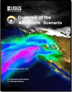 The U.S. Geological Survey,
Multi Hazards Demonstration Project (MHDP) uses hazards science to improve resiliency of communities
to natural disasters including earthquakes, tsunamis, wildfires, landslides,
floods and coastal erosion. The project engages emergency planners,
businesses, universities, government agencies, and others in preparing for
major natural disasters. The U.S. Geological Survey,
Multi Hazards Demonstration Project (MHDP) uses hazards science to improve resiliency of communities
to natural disasters including earthquakes, tsunamis, wildfires, landslides,
floods and coastal erosion. The project engages emergency planners,
businesses, universities, government agencies, and others in preparing for
major natural disasters.
The
project also helps to set research goals and provides decision-making
information for loss reduction and improved resiliency. The first public
product of the MHDP was the ShakeOut Earthquake Scenario published in May
2008. This detailed depiction of a hypothetical magnitude 7.8 earthquake on
the San Andreas Fault in southern California served as the centerpiece of the
largest earthquake drill in United States history, involving over 5,000
emergency responders and the participation of over 5.5 million citizens.
This document summarizes the next major public project for MHDP, a winter storm scenario called ARkStorm (for Atmospheric River 1,000). Experts have designed a large, scientifically realistic meteorological event followed by an examination of the secondary hazards (for example, landslides and flooding), physical damages to the built environment, and social and economic consequences. The hypothetical storm depicted here would strike the U.S. West Coast and be similar to the intense California winter storms of 1861 and 1862 that left the central valley of California impassible. The storm is estimated to produce precipitation that in many places exceeds levels only experienced on average once every 500 to 1,000 years. Extensive flooding results. In many cases flooding overwhelms the state’s flood-protection system, which is typically designed to resist 100- to 200-year runoffs. The Central Valley experiences hypothetical flooding 300 miles long and 20 or more miles wide. Serious flooding also occurs in Orange County, Los Angeles County, San Diego, the San Francisco Bay area, and other coastal communities. Windspeeds in some places reach 125 miles per hour, hurricane-force winds. Across wider areas of the state, winds reach 60 miles per hour. Hundreds of landslides damage roads, highways, and homes. Property damage exceeds $300 billion, most from flooding. Demand surge (an increase in labor rates and other repair costs after major natural disasters) could increase property losses by 20 percent. Agricultural losses and other costs to repair lifelines, dewater (drain) flooded islands, and repair damage from landslides, brings the total direct property loss to nearly $400 billion, of which $20 to $30 billion would be recoverable through public and commercial insurance. Power, water, sewer, and other lifelines experience damage that takes weeks or months to restore. Flooding evacuation could involve 1.5 million residents in the inland region and delta counties. Business interruption costs reach $325 billion in addition to the $400 billion property repair costs, meaning that an ARkStorm could cost on the order of $725 billion, which is nearly 3 times the loss deemed to be realistic by the ShakeOut authors for a severe southern California earthquake, an event with roughly the same annual occurrence probability. The ARkStorm has several public policy implications: (1) An ARkStorm raises serious questions about the ability of existing federal, state, and local disaster planning to handle a disaster of this magnitude. (2) A core policy issue raised is whether to pay now to mitigate, or pay a lot more later for recovery. (3) Innovative financing solutions are likely to be needed to avoid fiscal crisis and adequately fund response and recovery costs from a similar, real, disaster. (4) Responders and government managers at all levels could be encouraged to conduct risk assessments, and devise the full spectrum of exercises, to exercise ability of their plans to address a similar event. (5) ARkStorm can be a reference point for application of Federal Emergency Management Agency (FEMA) and California Emergency Management Agency guidance connecting federal, state and local natural hazards mapping and mitigation planning under the National Flood Insurance Plan and Disaster Mitigation Act of 2000. (6) Common messages to educate the public about the risk of such an extreme disaster as the ARkStorm scenario could be developed and consistently communicated to facilitate policy formulation and transformation. These impacts were estimated by a team of 117 scientists, engineers, public-policy experts, insurance experts, and employees of the affected lifelines. In many aspects the ARkStorm produced new science, such as the model of coastal inundation. The products of the ARkStorm are intended for use by emergency planners, utility operators, policymakers, and others to inform preparedness plans and to enhance resiliency. |
URL: http://pubs.usgs.gov/of/2010/1312/
Page Contact Information: USGS Publications Team
Page Last Modified: Saturday, 12-Jan-2013 17:31:11 EST
From USGS @ http://pubs.usgs.gov/of/2010/1312/
For more information about megafloods see http://nexusilluminati.blogspot.com/search/label/mega%20flood
For more information about pole shift see http://nexusilluminati.blogspot.com/search/label/pole%20shift
- Scroll down through ‘Older Posts’ at the end of each section
Hope you like this
not for profit site -
It takes hours of work every day
to maintain, write, edit, research, illustrate and publish this website from a
tiny cabin in a remote forest
Like what we do? Please give enough
for a meal or drink if you can -
Donate any amount and receive at least one New Illuminati eBook!
Please click below -
Videos - http://youtu.be/L7X8FTGCHGs
http://youtu.be/vJKTLuvGAU4?list=UUTiL1q9YbrVam5nP2xzFTWQ
http://youtu.be/8P-N-HA9iS8
For further enlightening
information enter a word or phrase into the random synchronistic search box @ http://nexusilluminati.blogspot.com
And see
New Illuminati – http://nexusilluminati.blogspot.com
New Illuminati on Facebook - https://www.facebook.com/the.new.illuminati
New Illuminati Youtube Channel - http://www.youtube.com/user/newilluminati/feed
New Illuminati on Google+ @ https://plus.google.com/115562482213600937809/posts
New Illuminati on Twitter @ www.twitter.com/new_illuminati
New Illuminations –Art(icles) by
R. Ayana @ http://newilluminations.blogspot.com
The Her(m)etic Hermit - http://hermetic.blog.com
The Prince of Centraxis - http://centraxis.blogspot.com (Be Aware! This link leads to implicate & xplicit
concepts & images!)
DISGRUNTLED SITE ADMINS PLEASE NOTE –
We provide a live link to your original material on your site (and
links via social networking services) - which raises your ranking on search
engines and helps spread your info further! This site is
published under Creative Commons Fair Use Copyright (unless an individual
article or other item is declared otherwise by the copyright holder) –
reproduction for non-profit use is permitted & encouraged, if you
give attribution to the work & author - and please include a (preferably
active) link to the original (along with this or a similar notice).
Feel free to make non-commercial hard (printed) or software copies or
mirror sites - you never know how long something will stay glued to the web –
but remember attribution! If you like what you see, please send a donation (no
amount is too small or too large) or leave a comment – and thanks for reading
this far…
Live long and prosper! Together we can create the best of all possible
worlds…
From the New Illuminati – http://nexusilluminati.blogspot.com
I didn't see mentioned that when highly charge particles pass an object like earth that earth in turns builds up a charge which would help to repel the effects of the solar winds.
ReplyDeleteTrue - but only up to a point; inversely and more relevant may be the concurrent decline in solar activity of late
DeleteIt's a worrying thought, all this shifting. How much shifting can take place before we start to see disastrous effects?
ReplyDeleteThis post was very well written, and it also comprises a lot of useful facts. I enjoyed your differentiated way of composing the post. Thanks, you have made it very simple for me to realise.
ReplyDeletecheap signs