Velikovsky and the 3,600 Year Doomsday Signature
Could Super Solar Flares Take Us
Back To 5000 BC?
Solar Coronal Mass Ejection
What are some of the FACTS that Velikovsky located and put as pieces of the puzzle into the whole? I quote from Earth in Upheaval:
Velikovsky’s Earth in Upheaval - The Ivory Islands, pages 4-6
In 1797 the body of a mammoth, with flesh, skin, and hair, was found in northeastern Siberia. The flesh had the appearance of freshly frozen beef; it was edible, and wolves and sled dogs fed on it without harm. The ground must have been frozen ever since the day of their entombment; had it not been frozen, the bodies of the mammoths would have putrefied in a single summer, but they remained unspoiled for some thousands of years. In some mammoths, when discovered, even the eyeballs were still preserved.
(All) this shows that the cold became suddenly extreme and knew no relenting afterward. In the stomachs and between the teeth of the mammoths were found plants and grasses that do not grow now in northern Siberia … (but are)... now found in southern Siberia. Microscopic examination of the skin showed red blood corpuscles, which was proof not only of a sudden death, but that the death was due to suffocation either by gases or water.
Was Velikovsky wrong? Not by a long shot. Recently more evidence, and more carcasses, have been unearthed, one in Finland, an episode that was published in Discovery magazine and on TV shows in 1999. I quote from the pages of the Troubled Times website.
According to Discovery magazine, April 1999, the American Mastodon roamed here for about 4 million years until about 11,500 years ago. Another type, the Mammuthus primigenius, roamed around 400,000 years until 3,900 years ago. Both extinction times could be multiples of 3,600 years.
The heyday of the woolly mammoth was the Pleistocene Epoch, stretching from 1.8 million years ago to the end of the last ice age 11,000 years ago. Mammoths thrived particularly well in Siberia, where dry grasslands once stretched for hundreds of miles, supporting a vibrant ecosystem of mammoths, bison, and other jumbo herbivores. ..
The mammoth fossils on Wrangel Island are the youngest that have ever been found. It was there, apparently, that mammoths made their last stand. They died out only 3,800 years ago.
Then, an excerpt from a recent Discovery program on the frozen mammoth carcasses:
It had always been thought that the mammoth died out about ten thousand years ago, with the end of the ice age, but the tusk appeared to be 7,000 years old. It was so unlikely, so Buttanyan tested five more tusks, but the new dates pointed to an even more remarkable conclusion.
Hidden up here [Rangell Island] in the Arctic, the mammoth hadn't just survived the end of the ice age, it was walking these hills at the time of the Egyptian Pharaos, only 3500 years ago. This discovery has led to the re-examination of the complex chain of 'cause and effect' that made mammoths die out everywhere else.
And the Zetas state it is NO accident that their frozen state indicates the crust of the Earth moved INTO the polar circle. This is what happens during pole shifts.
ZetaTalk: Mastodons, written on Jul 15, 2001
The Mastodon [or mammoth] is a species that went extinct during the past few pole shifts, primarily when the grasslands they browsed in Siberia were drawn rapidly into the new polar circle. But where drawn into water and drown, and then far enough north, the Mastodons were flash frozen.
If the Mastodons were not flash frozen, they would be in some sort of state of decay - perhaps the skin preserved, but the internal organs a mush. This is not the case, as your recent documentaries on the frozen state of these preserved beasts shows!
So if flash frozen, and frozen steadily since that date, then how did the Mastodons get green grass and buttercups in their stomachs? A fast trot to the Arctic Circle? Does anyone presume they ate snow? These were herbivors! Their grasslands were moved during poles shifts.
The remains of Mastodons that were not far enough into the polar circle to be completely frozen are bones and the ivory that has been harvested from the Ivory Islands for centuries. The bodies rotted, the Ivory did not. A wealth of ivory, with no flesh to disturb those shipping the tusks off to become piano keys.
I quote again from Earth in Upheaval:
Velikovsky Earth in Upheaval Dropped Ocean Level, pages 181-183
Daly observed that in a great many places all around the world there is a uniform emergence of the shore line of 18 to 20 feet. In the southwest Pacific, on the islands belonging to the Samoan group but spread over two hundred miles, the same emergence is evident.
Nearly halfway around the world, at St. Helena in the South Atlantic, the lava is punctuated by dry sea caves, the floors of which are covered with water-worn pebbles, now dusty because untouched by the surf. The emergence there is also 20 feet.
At the Cape of Good Hope caves and beaches also prove recent and sensibly uniform emergence to the extent of about 20 feet.
Marine terraces, indicating similar emergence, are found along the Atlantic coast from New York to the Gulf of Mexico; for at least 1,000 miles along the coast of eastern Australia; along the coasts of Brazil, southwest Africa, and many islands in the Pacific, Atlantic, and Indian Oceans.
The emergence is recent as well as of the same order of magnitude, (20 feet). Judging from the condition of beaches, terraces, and caves, the emergence seems to have been simultaneous on every shore.
In (Daly's) opinion the cause lies in the sinking of the level of all seas on the globe. Alternatively, Daly thinks it could have resulted from a deepening of the oceans or from an increase in their areas. Of special interest is the time of the change. Daly estimated the sudden drop of oceanic level to (have occurred) some 3,000 to 4,000 years ago.
There's that multiple of 3,600 again! Was Velikovsky wrong? Not by a long shot!
Scientists Challenge Conventional Sea Level Theory –
ABC News, December
3, 1999
Australian scientists say they have discovered evidence of rapid change in world sea levels and of a dramatic fall in geologically recent times - directly challenging current conventional wisdom.
Dr Robert Baker of the University of New England, in the New South Wales country town of Armidale, has tapped the secrets of worm coatings on once-submerged rocks to shake established theory that sea levels are presently as high as they have ever been.
Based on height measurements of worm coatings on rocks now well above sea level, and carbon dating tests which show them to be as recent as 3,500 years old, Baker argues that sea levels have not been steady since the last ice age, as is commonly believed.
Instead, he told Australia's ABC television, it changed rapidly 3,000-5,000 years ago. It means that the whole natural system is unstable. Baker and his colleagues at New England University say the sea level may have fallen quickly 3,500 years ago, by as much as a meter in just 10-50 years.
The conventional wisdom has been that sea levels haven't been higher. (Contrary) evidence was something that they weren't prepared to accept. Baker's theories, which he first aired 20 years ago, were initially rejected, but are now about to receive a wider audience with their publication in the respected journal Marine Biology.
3,500 years ago? Humm, pretty close to that 3,600 signature we're tracking. And if humans struggle with the cause, the Zetas, as usual, can explain.
ZetaTalk: Prior Shift, written on Mar 15, 1998.
You will not find the prior South Pole, as there, out over water, a 3,600 old melt and rebuilding left no trace. But the prior North Pole should leave no doubt, as the Island of Greenland, with volcanoes melting the glaciers away in great floods, is still more heavy with ice than all that has accumulated over the current water born poles to date, within the past 3,600 years.
Prior to the last pole shift there was a slightly colder Europe, a slightly warmer Russia. And why did the continents rend, so that the oceans dropped such a significant degree into the rifts, during the last shift? The crust was jerked to and fro, rapidly.
The violent passage was enough to heave the floor of the Red Sea, and to heap the waters up into glass mountains, so a desperate band of Jews could dash forward to safety, with this dash their only choice other than a brutal and vengeful death for all.
If the deep ocean rift in the Atlantic was where the waters of the oceans went, to drop the sea level 18-20 feet worldwide, has this ever been the reverse? I quote from the respected Journal Science.
Antarctic Ice Sheet Key to Sudden Sea Level Rise
University of Toronto, April 2002, Volume 2, Issue 3
Physicists from Canada, the United States and Britain have concluded that a massive and unusually abrupt rise in sea level about 14,000 years ago was caused by the partial collapse of ice sheets in Antarctica, solving a mystery scientists have been heatedly debating for more than a decade.
Near the end of the last Ice Age, the Earth's sea level rose over 20 metres - four times faster than usual for that time period and at least 20 times faster than sea levels are rising now, report geophysicists. The cause of this event - called the global meltwater pulse 1A, first identified in 1989 - has been unknown until now.
The scientists say their research not only pinpoints the source of the meltwater pulse, it also makes the case that significant climatic events can occur very rapidly and unpredictably.
There's that 3,600 signature again, as 14,200 is a precise multiple of 4 * 3,600!
Frozen mammoths and mastodons, falling and rising sea levels, what else?
I quote again from Earth in Upheaval:
Velikovsky Earth in Upheaval Shifting Poles, pages 111, 44, and 46
All other theories of the origin of the Ice Age having failed, there remained an avenue of approach which already early in the discussion was chosen by several geologists: a shift in the terrestrial poles. If for some reason the poles had moved, old polar ice would have moved out of the Arctic and Antarctic circles and into new regions.
 Shackleton, during his expedition to Antarctica in
1907 found fossil wood in the sandstone. Then he discovered 7 seams of coal.
The seams are each between 3 and 7 feet thick. Associated with the coal is
sandstone containing coniferous wood.
Shackleton, during his expedition to Antarctica in
1907 found fossil wood in the sandstone. Then he discovered 7 seams of coal.
The seams are each between 3 and 7 feet thick. Associated with the coal is
sandstone containing coniferous wood.Spitsbergen in the Arctic Ocean is as far north from Oslo in Norway as Oslo is from Naples. Heer identified 136 species of fossil plants from Spitsbergen. Among the plants were pines, firs, spruces, and cypresses, also elms, hazels, and water lilies.
At the northernmost tip of Spitsbergen Archipelago, a bed of black and lustrous coal 25 to 30 feet thick was found. (Spitsbergen) is buried in darkness for half the year and is now almost continuously buried under snow and ice.
At some time in the remote past corals grew and are still found on the entire fringe of polar North America - in Alaska, Canada, and Greenland. In later times fig palms bloomed within the Arctic Circle.
Hapburg, a compatriot of Velikovsky, suggested that a crustal shift was the most like explanation for the wandering poles phenomena, and it certainly is an explanation for the Ice Ages. How could it be that the last Ice Age, over France, was possible when at the SAME TIME Siberia, at the same latitude, was warmer, grasslands, where great numbers of mammoths grazed, herbivores, cousins of elephants, needing to eat grass, year round. Did the Sun wink out as it passed over France, then blaze when it passed over Siberia? Clearly, France was further North, and Siberia further South, at that time.
ZetaTalk: Wandering Poles, written on Feb 15, 2002.
Confusion exists over why the ice in Antarctica dates back, apparently, for many pole shift periods. If one analyses the last few shifts, it becomes apparent that the South Pole was either over, part way, Antarctica, or nearby in the ocean.
When a pole is over water, near land, the land mass retains its ice, under the influence of this large block of ice afloat. This is due to cold water washing against the land mass, as well as air currents. As we have stated in ZetaTalk,
The prior shift moved the North Pole from Greenland to its present location. Prior to that, it was over the East Siberian Sea, having pulled Siberia northward where the largest number of mammoth dieoff occurred. Tracing the North Pole over the past few shifts, one sees that it spent a time over Scandinavia where it resided between the 4th and 5th shift back.
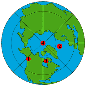 When it moved from Scandinavia into the Arctic
north of Siberia, Europe warmed up, its glaciers melting. Prior to Scandinavia,
the North Pole centered over North America.
When it moved from Scandinavia into the Arctic
north of Siberia, Europe warmed up, its glaciers melting. Prior to Scandinavia,
the North Pole centered over North America.The last ice age, over France, supposedly ended 10,000 years ago. 10,800 being a multiple of 3,600, that's pretty close to the 3,600 signature!
According to the September 10, 1996 issue of the Seattle Times
The lodgepole pine forest suddenly died 10,900 years ago (3633 x 3).
"The weather here changed so fast and so severely that the forest of the lodgepole pine that had succeeded Ice Age glaciers died in a blink."
What happened to make Seattle so suddenly cold, 10,900 years ago? Why, the crust moved, warming France and Scandinavia, and putting the cold spot someplace else.
Per the Zetas, the Ice Ages over France and Scandinavia were between 4 and 5 pole shifts back. That would put this time frame from between 14,400 years and 18,000 year ago.
Per Early Man in the New World by Kenneth MacGowan, published in 1950, there are charts of major glacial changes 18,000 years ago (3600 x 5), 25,000 years ago (3570 x 7), 40,000 years ago (3636 x 11), and 65,000 years ago (3611 x 18)!
What about this 3,600 year signature? What does Velikovsky have to say?
Velikovsky: Earth in Upheaval
Times and Dates, pages 202-203
Times and Dates, pages 202-203
Careful investigation by W.A. Johnston of the Niagara River bed disclosed that the present channel was cut by the falls less than 4,000 years ago. And equally careful investigation of the Bear River delta by Hanson showed that the age of this delta was 3,600 years.
The study by Claude Jones of the lakes of the Great Basin showed that these lakes, remnants of larger glacial lakes, have existed only about 3,500 years. Gales obtained the same result on Owen Lake in California and also Van Winkle on Abert and Summer lakes in Oregon.
Radiocarbon analysis by Libby also indicates that plants associated with extinct animals (mastodons) in Mexico are probably only 3,500 years old. Similar conclusions concerning the late survival of the Pleistocene fauna were drawn by various field workers in many parts of the American continent.
Suess and Rubin found with the help of radiocarbon analysis that in the mountains of the western United States ice advanced only 3000 years ago.
The Florida fossil beds at Vero and Melbourne proved - by the artifacts found there together with human bones and the remains of animals, many of which are extinct - that these fossil beds were deposited between 2,000 and 4,000 years ago.
From observations on beaches in numerous places all over the world, Daly concluded that there was a change in the ocean level, which dropped sixteen to twenty feet 3,500 years ago. Kuenen and others confirmed Daly's findings with evidence derived from Europe.
Others have also taken note. Lloyd Pye reports:
3600 in geo evidence by Lloyd Pye: Quotes from Cyclostratigraphy
Stratigraphy is the science of reading geological strata, which are ribbon-like layers of rock that were at one time sand, soil, or volcanic outflow. Sand or soil was washed into place by long extinct rivers, or settled to the bottom of long extinct seas or lakes. Lava flows appear much quicker and are usually much thicker.
Strata can reveal many things.. What was the magnetic alignment of the Earth when a strata was deposited? Was magnetic north where it is today? Pointing to the equator? Or to where Zanzibar is now? Strata are the telltales of geologic history. They can provide views into the past that are often remarkable and sometimes astonishing.
One of the lesser known but highly important aspects of stratigraphy is that it provides an unambiguous record of global catastrophes. Shifts of the magnetic poles are only one of a range of events chronicled in stone. Earthquakes of great antiquity can be read and dated. Volcanic eruptions.
Mountains rise and fall. Rivers change course. Flood plains shrink or expand. Glaciers wax and wane. All leave scars on the Earth that end up in the geologic record. But what causes the seasons to change? Better yet, what causes Ice Ages? What causes the many fluctuations recorded within each Ice Age? Is there a pattern to any of it? Can there be a recognizable cycle in a river's seasonal flooding, or Earth's cataclysmic Ice Ages? Yes. ...
As Roger Cunningham was reading through the section of [the Second Edition of the Encyclopedia of Human Evolution and Prehistory, Farland Publishing, year 2000, a ] book dealing with these matters, something caused him to put on his thinking cap and, being a number cruncher at heart, he decided to play around with what he had read. It wasn't long before one very important number literally leaped off the calculator at him: 3600. ...
And none other than Potsdam Institue for Climate Impact has found a similar 3,600 signature.
ABC News, July 15, 1999:
The rains stopped coming, the temperature rose and the great grasslands of North Africa turned to desert a few thousand years ago - changes that may have helped spur development of civilization in the Nile Valley. 4,000 to 3,600 years ago, according to a paper published today by the journal Geophysical Research Letters, was very severe, ruining ancient civilizations and socio-economic systems.
A team of researchers headed by Martin Claussen of Germany's Potsdam Institute for Climate Impact Research analyzed computer models of climate over the past several thousand years. They concluded that the change to today's desert climate in the Sahara was triggered by changes in the Earth's orbit and the tilt of Earth's axis.
At that time, the Northern Hemisphere received more summer sunlight, which amplified the African and Indian summer monsoon, they reported. The switch in North Africa's climate and vegetation was abrupt. In the Sahara, we find an abrupt decrease in vegetation from a green Sahara to a desert shrubland within a few hundred years.
So, what else happened 3,600 years ago? We've got the Jewish Exodus, the last mammoths going extinct, the sea level dropping world wide by 18-20 feet, the Sahara drying up.
Anything else? Well, 3,600 years ago, Thera, a monstrous volcano in the Mediterranean, erupted, as did Vesuvius. The eruption at Thera was 20 times as massive as Krakatoa in 1883.
According to current data, the last two great eruptions of Vesuvius occured in 3580 B.C.E and 79 C.E. (the latter being the eruption which buried Pompei and Herculaneum). Both Krakatoa and Thera have a Volcanic Explosivity Index or 6 which rates them as "colossal".
Science Digest, Sep/Oct '80
When Krakatoa exploded on August 26, 1883, it erupted noisily. It could be heard as much as 3,000 miles away on Rodrigues Island in the Indian Ocean. Vibrations shattered shop windows 80 miles off. The energy; released in the main explosion has been estimated to be equivalent to an explosion of 150 megatons of TNT.
Christos G. Doumas, Thera - Pompeii of the Ancient Aegean, p. 141
And trees in Sweden show the mark of this explosion, and help establish the date as 1628 BC. Given that the Zetas say the actual passage period for Planet X, aka Nibiru, is 3,657 years, this puts the date of the passage very near, well, NOW!
Ancient Trees May Explain Story of Atlantis Associated Press, September 14, 2000
Researchers say ancient pine tree stumps found in a Swedish peat bog may hold a record of the great volcanic blast. Major volcanic eruptions have been known to blast enough dust into the atmosphere to cause frosts and limit crop growth, and one of the most powerful such blasts occurred when the Greek island of Santorini blew up in the mid-1600s B.C.
[Carbon] dating and the severe magnitude of this phenomenon suggest that it can be ascribed to the 1628-27 B.C. event, hence providing new evidence of a wider, more northerly area of influence, the team of Swedish scientists reported in the Sept. 15 issue of Geophysical Research Letters.
And in China, it was written during the reign of Emperor Qin c.1600 B.C.
Chieh Dynasty
In the twenty-ninth year of King Chieh [the last ruler of Hsia, the earliest recorded Chinese dynasty], the Sun was dimmed... the Sun was distressed... during the last years of Chieh ice formed in [summer] mornings and frosts in the sixth month [July]. Heavy rainfall toppled temples and buildings... Heaven gave severe orders. The Sun and Moon were untimely. Hot and cold weather arrived in disorder. The five cereal crops withered and died.
Sounds like the distress preceding a pole shift, with the Sun and Moon untimely. And what about 7,200 years ago, times 2?
Geo Science, Tsunami Along the South Coast of New South
Wales, Australia
The first event probably occurred concomitantly with the rise of Holocene sea-level near modern levels around 7000 before the present. The impact of these tsunami upon the coastal landscape has been profound. Several signatures provide estimates of the magnitude of run-up of these events.
The largest tsunami waves swept sediment across the continental shelf and obtained flow depths of 15-20 m at the coastline with velocities in excess of 10 meters per second. Along cliffs, and especially at Jervis Bay, waves reached elevations of 40-100 m with evidence of flow depths in excess of 15 m.
Recent work indicates that the southeast coast of Australia may not be the only coast to be affected by catastrophic tsunami. The geomorphic signatures of such events have been found on Lord Howe Island in the mid-Tasman Sea, along the north Queensland coast and along the northwest coast of Western Australia.
Bedrock sculpturing features have been identified on the islands of Hawaii and along the east coast of Scotland. The latter location is within the zone affected by the tsunami generated by a large submarine landslide near Storegga, Norway also 7,000 years ago.
Humm, a tsunami affecting Australia and Scotland and Norway, at the same time? Sounds global to me.
BBC
A giant wave flooded Scotland about 7,000 years ago, a scientist revealed on Friday. The tsunami left a trail of destruction along what is now the eastern coast of the country. Scientists believe a landslide on the ocean floor off Storegga, south-west Norway, triggered the wave.
Speaking at the British Association Festival of Science in Glasgow, Professor David Smith said a tsunami could strike again in the area but the probability was extremely unlikely. It looks as if those people were happily sitting in their camp when this wave from the sea hit the camp, Professor Smith of the department of Geography at Coventry University told BBC News Online.
And did this tsunami affecting Norway and Scotland, a landslide along the coastline there, cause the Black Sea to form? All these events, around 7,200 years ago, a multiple of 3,600, are oddly coincidental. That 3,600 year signature again.
For Noah's Flood, a New Wave Of Evidence:
Washington Post, November 18, 1999
Scientists have discovered an ancient coastline 550 feet below the surface of the Black Sea, providing dramatic new evidence of a sudden, catastrophic flood around 7,500 years ago - the possible source of the Old Testament story of Noah.
A team of deep-sea explorers this summer captured the first sonar images of a gentle berm and a sandbar submerged undisturbed for thousands of years on the sea floor. Now, using radiocarbon dating techniques, analysts have shown that the remains of freshwater mollusks subsequently dredged from the ancient beach date back 7,500 years and saltwater species begin showing up 6,900 years ago.
The findings offer independent verification of a theory advanced by Columbia University geologists William Ryan and Walter Pitman that the Black Sea was created when melting glaciers raised the sea level until the sea breached a natural dam at what is now the Bosporus, the strait that separates the Mediterranean Sea from the Black Sea.
An apocalyptic deluge followed, inundating the freshwater lake below the dam, submerging thousands of square miles of dry land, flipping the ecosystem from fresh water to salt practically overnight, and probably killing thousands of people and billions of land and sea creatures, according to Ryan and Pitman.
The two scientists described the catastrophe in their book Noah's Flood, based on 30 years of research that began with coring samples showing the same abrupt transition from lake to sea that Ballard confirmed with his dredge. No one had ever actually seen the old shoreline, however, until Ballard's team captured sonar images of it in August.
Well, they're not taking into consideration what happened in Norway and Scottland, micro-examining the event. And volcanoes were also involved at that same time period. Did the tsunami cause the volcano?
According to the September 10, 1996 issue of the Seattle Times: the research ship JOIDES (Joint Oceanographic Institutions for the Deep Earth Sampling) Resolution "could easily see the light colored ash deposited from the eruption of Oregon's Mount Mazama 6,950 years ago. That titanic eruption created Crater Lake and threw out at least 40 times as much magma as Mount St. Helens did in 1980 and serves as a useful marker to date mud layers.
Water rushing into the coastlines of Australia, submerging western Scotland, inundating Norway, and moving enough earth to block the Black Sea from the Mediterranean. Does water move like this, during a pole shift?
ZetaTalk: Tidal Waves, written prior to July 15, 1995
As great as the danger to humans and the fauna and flora of the Earth that earthquakes bring, greater still is the devastation that the shifting waters will bring. There are several factors at play. Water is more liquid than the core of the Earth, and certainly more liquid than terra firma.
Where the Earth, dragged by its core, is shifting into a new alignment with [Planet X], its waters resist greatly. Thus the waters slosh over the nearby land, in the direction opposite to the shift. The Earth's record of gigantic tidal waves, which the establishment is desperate to explain in other than pole shift terms, is caused by the frequent pole shifts.
I quote again from Velikovsky's Earth in Upheaval
Whales in the Mountains, pages 46-49
Bones of whale have been found 440 feet above sea level, north of Lake Ontario; a skeleton of another whale was discovered in Vermont, more than 500 feet above sea level; and still another in the Montreal- Quebec area, about 600 feet above sea level. Although the Humphrey whale and beluga occasionally enter the mouth of the St. Lawrence, they do not climb hills.
How does a whale arrive 500 feet above sea level, as this is an established fact, one the scientific community cannot even begin to explain.
ZetaTalk: Flood Tide, written on Jun 15, 2001
Tidal waves are often shown as rising high, a tower of water crashing down upon hapless humans standing in horror on a beach. Where a wave generated by an underwater displacement, such as occurs when plates adjust due to subduction during an earthquake, will roll in a deadly line of pressure until the shore is reached and then rise up when the depth of water is reduced as the wave rolls up the beach, this does not occur when the whole of the ocean is on the move.
It is rather a flood tide, as the oceans are climbing out of their beds, into higher ground, so the leading edge is the highest point of the wave. In Tsunamis, a single line of pressure moves through the ocean, transferring water pressure rapidly from the quake point to where it must stop, at land, thus finally crashing upon a beach.
During a pole shift, there is no single line of pressure, the ocean as a whole is on the move because it stays behind while the crust moves, and thus rolls up on land onto the coastline being pulled under it. This is a flood tide, with the lip of the water being its highest point, rising like a silent tide endlessly on the rise, the wave rolling inland without a crashing back and forth, just a steady progressive inundation.
Waves caused by an asteroid crash are akin to what children see when they drop a boulder into a pond or puddle. As with a Tsunami caused by a subducting plate, where the water is under great pressure at a certain point and transfers this pressure in a line in the direction it was first thrown, the boulder will cause a sudden line of water pressure away from the impact point.
That water rising directly upward drops quickly to the surface, the splash. But the water within the pond moves the line of pressure outward, visible only as a ripple on the surface of the water until the edge of the pond is reached where it becomes a lapping wave.
Asteroid generated waves are thus tall, crashing upon the shore. Whale bones on mountain tops well inland were not lifted by Tsunami waves, nor carried inland atop such a wave. A whale would not be close enough to the shore to be caught in such an occurrence.
They arrived at these inland mountain tops because the entire ocean was moving, and they could not escape the momentum. Thus caught, they were deposited in rocky crags where fast flowing waters moved quickly away from them through cracks, too tight a squeeze for the hapless whale left floundering behind.
And 10,800 years ago? 3 multiples back of 3,600?
Ice Age Forest Gives a Global Warning
Fox News, Feb. 25, 2000
Fox News, Feb. 25, 2000
The discovery of a forest 11,000 years old buried intact in Michigan, with tree tops poking through the sand, has raised alarm about the possible speed of global warming. The five-acre forest of hundreds of spruce, just over ten miles from the shore of Lake Superior, was covered with sand and water when a nearby glacier melted at the end of the Ice Age.
What has shocked scientists is that analysis of the tree-rings shows that the climate warmed so rapidly that it left no mark on the normal growth of the trees before they were flooded. The conclusion, based on the tree rings, is that there was no real warning of the dramatic warming that caused the glacier to melt, said Theodore Bornhorst, Professor of Geology at Michigan Technological University.
And so it goes, the Earth holding evidence to the periodic passage of Planet X, the 3,600 signature.
ZetaTalk: Past Cataclysms, written on Feb 15, 1996.
The Earth bears witness to the cataclysms in her past and their periodic occurrence. Beyond her deep wound in the Pacific basin, and beyond the drift of her continents, there are scars more palpable by man.
Mountain cliffs, which rise sheer in many cases thousands of feet, represent tearing of solid rock. These stands before mankind, who even make a hobby of scaling their heights, ignored in their deeper meaning. Have any experiments been done to determine how much force would be required to tear rock of this depth? None have. The reason lies in the equally deep desire of mankind to avoid thinking about the Earth's past cataclysms.
Beneath the sea in the Bahamas lies evidence of civilizations that went under the waves - highways and highway markers, clearly manmade. These areas have been explored by many fortune hunters, recorded by camera, and published in full color repeatedly.
Likewise ancient Incan cities stand so high in altitude that the cities could not have been built, much less lived in. Yet the scientific community continues to claim that Earth changes happen gently, inch by inch, at the pace experienced during the memory of their current civilization.
Antarctica bears witness to her past as a steamy swamp, and likewise the North Seas, where oil is extracted. Likewise the temperate regions are scared by what is termed the Ice Ages, where these regions were as snow and ice packed as the poles.
A clue to these changes lies in the magnetism frozen in hardened lava, which demonstrates that Magnetic North and South changed now and then. Has any adequate explanation been proffered by the scientific community?
None has, as all the explanations have the Earth's thin crust remaining in place, as the thought that they are standing on a raft that can move on the sea of magma beneath them is too frightening to contemplate.
Did you also know the Norwegians put Billions into any
NASA
project that had to do with DEEP SPACE plus INFRARED mapping?? Very Odd ??
project that had to do with DEEP SPACE plus INFRARED mapping?? Very Odd ??
I
have collected other IMPORTANT data the points to the fact that 12-2012 is not
an actual dooms-day-date but instead a very special point in time WHEN the
ancients could start collecting accurate data on THE DESTROYERS exact flight
path.
THE
DESTROYER has such a wild orbit that any prediction on the devastation level
and areas that will be hardest hit can ONLY be calculated on the month of
12-2012. It is some time after that date that we will know our fate. Each
encounter is totally different every 3600 years.
 The 12-2012 date is akin to a weather report date.
For Noah's time is was simply 40 days of rain so that was an easy episode to
'ride-out' and THE DESTROYER's path was 'meek'
The 12-2012 date is akin to a weather report date.
For Noah's time is was simply 40 days of rain so that was an easy episode to
'ride-out' and THE DESTROYER's path was 'meek'12-2012 is not the actual dooms-day-date but it is instead the day we can gather the first real accurate flight path data of how close the path will be to earth, how much damage and WHEN…
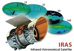
*The
Infrared Astronomical Satellite (IRAS) was the first-ever space-based observatory to perform a survey of the entire
sky at infrared wavelengths.
Launched
on January 25, 1983, its mission lasted ten months. The telescope was a joint project of the United States
(NASA) and the Netherlands
(NIVR)
OTHER ODD FACTS - Makes Ya Think
--
or 3600 seconds in an "HOUR" or "yar" - But how did this WHOLE concept of time measurement in fractions of the number 3600 begin???
We still tell time today in fractions of 3600 and no one person gives it a 2nd thought. Why in fractions of the number 3600????????????
A word "SHAR" is ancient Sumerian for 3600 years and from THAT we divided time down to finally minutes and seconds again 3600
Why would a race of people like the ancient Sumerian's actually have the word "SHAR" that mean's 3600 years?
That is an odd number of years to actually commit a written word to do you not think so? I do not believe in coincidences.
Excerpted from Hydrogen Appliances @ http://www.hydrogenappliances.com/moreX.html
For more information about the ideas of Immanuel Velikovsky see http://nexusilluminati.blogspot.com/search/label/Velikovsky
- See ‘Older Posts’ at the end of each section
This is a ‘not for
profit’ site -
But if you like what we do please
buy us a meal if you can
Donate any amount and receive at least one New Illuminati eBook!
Please click in the
jar -
For further enlightening
information enter a word or phrase into the random synchronistic search box @ http://nexusilluminati.blogspot.com
And see
New Illuminati – http://nexusilluminati.blogspot.com
New Illuminati on Facebook - https://www.facebook.com/the.new.illuminati
New Illuminati Youtube Channel - http://www.youtube.com/user/newilluminati/feed
New Illuminati on Google+ @ https://plus.google.com/115562482213600937809/posts
New Illuminati on Twitter @ www.twitter.com/new_illuminati
The Her(m)etic Hermit - http://hermetic.blog.com
The Prince of Centraxis - http://centraxis.blogspot.com (Be Aware! This link leads to implicate &
xplicit concepts & images!)
DISGRUNTLED SITE ADMINS PLEASE NOTE –
We provide a live link to your original material on your site - which
raises your ranking on search engines and helps spread your info further! This site
is published under Creative Commons Fair Use Copyright (unless an individual article
or other item is declared otherwise by copyright holder) – reproduction for non-profit
use is permitted & encouraged, if you give attribution to the work &
author - and please include a (preferably active) link to the original (along
with this or a similar notice).
Feel free
to make non-commercial hard (printed) or software copies or mirror sites - you
never know how long something will stay glued to the web – but remember
attribution! If you like what you see, please send a donation (no amount is too
small or too large) or leave a comment – and thanks for reading this far…
Live long
and prosper!
From the New
Illuminati – http://nexusilluminati.blogspot.com
I just want to say to The New Illuminati Thank You for allowing me a self educated person to share in your wonderful world of truth and freedom.I think George Washington just smiled.There are no other words than THANK YOU...
ReplyDelete