Prehistoric tsunami in Australia
Identification of a range of features or signatures imprinted upon the landscape by large tsunami has allowed us to construct a record of palaeo- (prehistoric) tsunami. These signatures include sedimentary deposits and erosional bedrock features.
Depositional and erosional signatures of tsunami
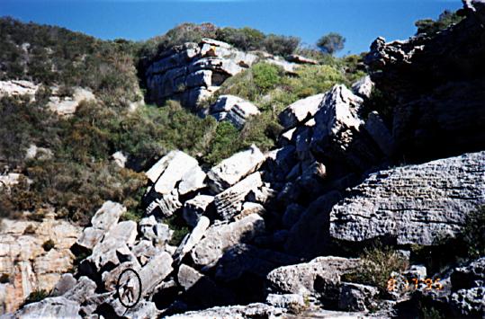
For example, there are numerous piles of boulders aligned like fallen dominoes along the top of cliffs at Jervis Bay, New South Wales. The waves that overwashed these cliffs also deposited shelly sand that can be radiocarbon dated around AD 1500. This event produced one wave that overran the 130 m high headland flanking the south of Jervis Bay.
The photographs in the linked windows show this evidence. At Gum Getters Bay, boulders as large as a boxcar were moved. They are stacked parallel with each other to the top of a 30 m high cliff. In this regard, cliff collapse did not produce the deposit. Rather the boulders were deposited from a wave that overwashed the cliff.
Imbricated boulders stacked against a thirty-metre high cliff face on the south side of Gum Getters Inlet, New South Wales, Australia. Some of these boulders are the size of a boxcar. Note the person circled for scale.
More dramatic are features carved into bedrock that render much of Australia's rocky coast so scenic. Multiple vortices in fast moving water can sculpture solid bedrock into many distinct features such as stacks, arches, and sea caves. Our web pages show many photographs of these features around the Australian coastline. Many of these features have been attributed, without substantiation, to long-term erosion by wind-generated waves.
However, some features lie beyond the reach of normal or high-energy wave attack and bear similarities to features carved by enormous floods that were last present on Earth during the Last Ice Age. Stacks such as Cathedral Rocks near Kiama on the New South Wales South Coast, and giant whirlpools on the sides of headlands were carved by vortices in tsunami flow within a few minutes.
A mega-tsunami approached the coastline from the southeast, overrode the headland, dropped into the sheltered embayment on the leeside, and then cut into the cliffs at Cathedral Rocks. Horizontal, eggbeater like vortices gouged out the stacks.. A sea cave was then bored into the cliffs by one of the vortices landward of the main stack.
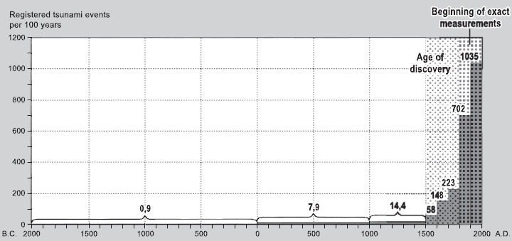
Some of the above events would be devastating were they to recur today near inhabited coastline. Fortunately, only two large events have been identified along the New South Wales coast over the past 10000 years. The size of the evidence is beyond the capability of earthquake-generated tsunami and alludes to a meteorite or comet hit with the ocean. The figure below presents a record of comet and meteorites for the last 2000 years.
The calibrated radiocarbon dates under the Mystic Fires of Tamaatea are from wood and peats burnt on the South Island of New Zealand. The Mystic Fires of Tamaatea refers to a Maori legend where fire from the sky scorched the Earth killing many people.
The radiocarbon dates of prehistoric tsunami events in Australia are based on shell collected from tsunami deposits along the New South Wales coast and from Lord Howe Island.
Also shown is the frequency of corrected radiocarbon ages from tsunami deposits along the New South Wales coast and Lord Howe Island. The panel entitled Fires of Tamaatea plots the frequency of corrected radiocarbon dates on burnt wood and peat from the South Island of New Zealand. This dates a Maori legend about the descent of fire from the sky that destroyed the landscape. The AD 1500 tsunami along the east coast of Australia corresponds to a peak in the comet and meteorite observations, and to the timing of Maori legends describing a comet hit.
Dates are now coming from tsunami deposits on the east coast of New Zealand confirming this age. Astronomers believe that a comet came into the inner solar system within the last 20,000 years and fragmented. The Earth periodically passes through the most concentrate part of the debris trail at 500-1500 year intervals. The evidence suggests that one such fragment might have struck the Australian-New Zealand region 500 years ago. Except for random meteorites, the Earth will not intercept this comet trail again until AD 3000.
While our east coast is not threatened by another comet- or meteorite-induced tsunami, tsunami generated by submarine slides cannot be ruled out. Radiocarbon dating suggests that an important tsunami occurs along the New South Wales coast every 1000 years or less. The source of these events is not difficult to envisage. There are over 170 slide scars on the continental shelf edge along the New South Wales coast. They have not been dated, but they are geologically recent. Any of them could cause a localised tsunami. Some slides are large.
One off northern Wollongong measures 20 km in length and 10 km in width. It would have generated a tsunami that affected a considerable length of coast south of Sydney. There is no detection system in place in Australia to warn against tsunami generated by nearby submarine slides. Even if there were, people would have only 20- 30 minutes to evacuate to safety. They could do it though.
Transcript, links and further information for 'Tsunami'
Narration
Forces of nature make great movie villains, big, powerful and very scary. But for the people of Papua New Guinea, Hollywood fiction became grim fact in July, when a tsunami slammed into the country's north coast
Such monster waves have many causes and devastating consequences. In Papua New Guinea, over 2,200 people died and thousands more were left homeless. Scientists scrambled to pin down the source of the destructive wave.
Associate Professor Ted Bryant
It looks like it might be a submarine land slide triggered by an earthquake event and it was on catastrophic proportions
Narration
Tsunamis have been wreaking havoc around the Pacific Rim for millennia. Yet they remain a confusing phenomenon. For instance, "tsunami" is Japanese for "harbour wave", not "tidal wave". And the mighty waves are often depicted incorrectly in the media.
Professor Joe Monaghan
For example in this newspaper you will see an artist's representation of a wave....one or two decisive waves. You get thumped by something immense.
Narration
Ordinary storm waves have tremendous destructive power. But tsunamis can travel at speeds of nearly 1,000 kilometers per hour and carry billions of tonnes of water. The most common trigger is an undersea avalanche or earthquake. The sudden shift of a huge volume of water sends the tsunami on its way.
As the front of a tsunami hits shallow water near shore, it slows. Faster moving water at the back catches up, and builds the wave to a height of 30 meters or more. Surprisingly, Australia has long been on the tsunami hit list, argues a leading Geomorphologist.
Ted Bryant bases his startling claim on a suite of geological evidence scattered all around the vast coastline. Ted's discovered what he calls the "signatures" of a tsunami: Things like piles of shells where they shouldn't be, ocean sand on hilltops, and peculiar rock formations. For instance, at Little Bay, south of Sydney, there are giant 10-tonne boulders, tossed well beyond the reach of ordinary stormy seas.
Associate Professor Ted Bryant
This boulder has been lightly settled out of flowing water and its made contact with the blocks underneath and if it had been tossed up it would have fractured these contacts and you can see that there's no fracturing between the two ah three boulders where they made contact....
This one has just settled out of the flow and so a tsunami's gone by and lost some of its energy so its dropped out of the flow gently onto the other blocks and the platform.
Narration
Ted claims that further south, near Wollongong, is another "signature" of that same tsunami, an enormous bowl-shaped structure.
Associate Professor Ted Bryant
Well we're standing on the side facing the wave's approach.. The wave's gone up over this head land and as the wave went over, you would have had about five minutes of water eight to ten meters deep but it slowly generated vortexes that sped up and when they reached the critical velocity they actually cut down through this bed rock and that's the circular depression the part which you see in the middle is the center of the vortex because the waves were moving and the water was moving slower than the vortex. It didn't erode as fast.
Narration
According to Ted, tsunamis the size of the vortex-carver were probably set rolling by asteroids. Impact, earthquake or undersea avalanche, he bets Australia will be struck again. It has already been hit by at least six tsunamis in the past 6,000 years.
Associate Professor Ted Bryant
The most recent big one we think occurred about fourteen hundred AD and that one was tossing material up sixty meters high ... and from other evidence around the Jarvis Bay region we think it may have been going up on top of eighty meter high cliffs.
Narration
Yet, the giant waves vary in size and shape, and haven't left their calling cards on every Australian beach. To find out why, mathematician Joe Monaghan puts tsunamis in a tank.
Professor Joe Monaghan
What you're going to see is a tsunami running onto shore . We're interested in how the tsunami breaks, what happens here when it meets beaches of different slope. We're interested in the way it runs ashore. We want to know how the sand has moved...
Leigh Dayton
Why is it important to know where the sand is after an experiment like this?
Professor Joe Monaghan
Well if you're like us and you want to find out about an ancient tsunami ... sediments ... material thrown up from the sea.
Narration
Based on experimental findings, Joe simulates real tsunamis, like the Papua New Guinea wave, which smashed into a lagoon.
Professor Joe Monaghan
The front of the tsunami...it will break..
Narration
Using similar scientific tools, Joe is tackling another complex problem: historical tsunamis, triggered by volcanic eruptions. He suspects the fall of the once mighty Minoan civilization of Crete, about thirty five hundred years ago, is linked to a known eruption on the Aegean island of Santorini.But how could a volcano be responsible?
Professor Joe Monaghan
They emit what are called pyroclastic flows, fast moving hot gas carrying a great deal of solid material that just pushes into the sea and in pushing into the sea it initiates these tsunamis.
Narration
To test his theory, Ted sets miniature pyroclastic flows off and monitors their waves. It's such a finicky process, he only manages one experiment a day. Still, a computer model based on the hard-won data shows Joe may be right. But with increasing insight into the secrets of tsunamis, why was Papua New Guinea caught off guard? After all, an international, Pacific-wide network of earthquake-sensitive seismographs, sea-level monitors and satellites produces tsunami alerts for member nations.
Australia is a participant, unlike Papua New Guinea. But even a warning system can be too little too late. And sometimes there's no accounting for curiosity.
Associate Professor Ted Bryant
In San Francisco in 1964, after the Alaskan earthquake there was a warning put out for the Pacific and it gave San Francisco about 6 hours. And ten thousand people made it down to the coast line to stand there watching the wave come.
Narration
Fortunately the wave passed them by. If Ted Bryant is right, though, coast-loving Australians are in line for a front row view of a tsunami...anytime. There's even a chance Hollywood will have it right.
Further Information
Associate Professor Ted Bryant
Geosciences
University of Woollongong
Professor Joe Monaghan
Maths Department
Monash University
Melbourne
images - http://digitaljournal.com/img/8/7/3/i/8/8/9/o/Australian-continent.jpg
http://www.uow.edu.au/content/groups/public/@web/@sci/@eesc/documents/mm/uow015608.jpg
http://www.printsasiaimages.com/632427467/110429060505HO343T38.jpg
https://blogger.googleusercontent.com/img/b/R29vZ2xl/AVvXsEgrDrCgPwSWcW3LBCvwJYrcK_p-rkAH-1vvyFqXigyKDJXdBBN1QMMZ0Emvvog4jjtVS7qKr8KvWFgpubfjYDfJ60ukuIsyR6HPIiKJP2xrbZevpUgkMApHY69pzyqixBA-IbK8IHO0b9Nc/s1600/SCHEFFERetal_2003_Tsunami_historic_events.jpg
http://www.greatdreams.com/weather/sri-lanka-wave.jpg
For further enlightenment see –
This material is published under Creative Commons Copyright – reproduction for non-profit use is permitted & encouraged, if you give attribution to the work & author - and please include a (preferably active) link to the original along with this notice. Feel free to make non-commercial hard (printed) or software copies or mirror sites - you never know how long something will stay glued to the web – but remember attribution! If you like what you see, please send a tiny donation or leave a comment – and thanks for reading this far…


